Morena district
| Morena district MOrena जिला | |
|---|---|
| District of Madhya Pradesh | |
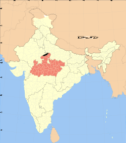 Location of Morena district in Madhya Pradesh | |
| Country | India |
| State | Madhya Pradesh |
| Administrative division | Chambal |
| Headquarters | Morena |
| Tehsils | 1. Morena, 2. Ambah, 3. Porsa, 4. Joura, 5. Sabalgarh and 6. Kailaras |
| Government | |
| • Lok Sabha constituencies | Morena (shared with Sheopur district) |
| • Assembly seats | 1. Sabalgarh, 2. Joura, 3. Sumawali, 4. Morena, 5. Dimani and 6. Ambah |
| Area | |
| • Total | 4,998 km2 (1,930 sq mi) |
| Population (2011) | |
| • Total | 1,965,137 |
| • Density | 390/km2 (1,000/sq mi) |
| • Urban | 22.56 |
| Demographics | |
| • Literacy | 72.1 |
| • Sex ratio | 839 |
| Major highways | NH3 |
| Website | Official website |
Morena district (Hindi: मुरैना जिला) is one of the 50 districts of the central Indian state of Madhya Pradesh. The name, Morena is derived from the mor + raina means the place where peacock is enormously found. Morena, which has an identity of being home to perhaps the largest number of peacocks in the India. The district is part of Chambal Division. The town of Morena is the district and divisional headquarters. The district has a widely dispersed population of 1,965,137 as of 2011. Morena is fifth district in state in density of population after Bhopal, Indore, Jabalpur, Gwalior. The district is mostly farmland, and trains are a popular form of transportation, although they connect only about 15% of the villages within Morena. Morena is famous for its mustard production and one of the most famous KS oils HQ is situated here. This region is dominated by Dandotiyas, Yadavs, Pachouris, Gurjars and Rajputs.[1]
Paan Singh Tomar and other famous dacoits who operated in and around Morena have etched a Robin Hood-esque romanticism on Indian psyche about this remote region.
History
Most of the territory of the present-day Morena district formed Tonwarghar District of the erstwhile princely state of Gwalior. After India's independence in 1947, the princely states acceded to the Government of India, and Morena District acquired its present boundaries with the addition of the princely state of Pahargarh in the south of the district. Morena District became part of the newly formed state of Madhya Bharat, which was merged into Madhya Pradesh on 1 November 1956.
ð₳==Geography== Morena is located at 26°18′N 78°00′E / 26.30°N 78.00°E. Geographically Morena is an interesting place as Madhya Pradesh touches two neighbouring states i.e. Rajasthan and Uttar Pradesh here. Morena touches Dholpur (Rajasthan) in North-West and Pinahat (Agra, Uttar Pradesh) in North-East. The neighbouring districts are Bhind, Gwalior, Shivpuri and Sheopur.
Divisions
Morena district comprises four sub-divisions: Morena, Ambah, Joura and Sabalgarh. Morena sub-division comprises a lone tehsil and a lone block: Morena. Ambah sub-division comprises two tehsils and blocks: Ambah and Porsa. Joura sub-division comprises Joura tehsil, which is further divided into two blocks: Joura and Pahargarh. Sabalgarh sub-division has two tehsils and blocks: Sabalgarh and Kailaras. Significant towns of this district are: Morena, Bamor, Ambah, Porsa, Joura, Sabalgarh, Kailaras and Jhundpura.
The district has six Vidhan Sabha constituencies: Sabalgarh, Joura, Sumawali, Morena, Dimani and Ambah. All of these are part of Morena Lok Sabha constituency.[2]
Demographics
According to the 2011 census Morena District has a population of 1,965,137,[3] roughly equal to the nation of Lesotho[4] or the US state of New Mexico.[5] This gives it a ranking of 236th in India (out of a total of 640).[3] The district has a population density of 394 inhabitants per square kilometre (1,020/sq mi) .[3] Its population growth rate over the decade 2001-2011 was 23.38%.[3] Morena has a sex ratio of 839 females for every 1000 males,[3] and a literacy rate of 72.07%.[3]
Famous personalities from Morena
- Jabar Singh Tomar, famous Lawyer and a great social reformer
- Seth Girwar Lal Pyare lal; Famous businessman and founder of seth girwar lal pyare lal siksha trust .
- Ram Prasad Bismil; Indian Revolutionary,Village-(Barbai)Morena
- Paan Singh Tomar; Famous Athlete Bhidosa(MORENA)
- Atal bihari bajpai ex-pm (bateshwar)
- Ashok Chhaviram Argal; (Member of parliament four times Morena & one time behind)
- Shree Krishna Singh Tomar(skt) Transporter And Business Man.
- Raja Pancham Singh Of Pahargarh State,Ex chairman of Distt.co operative Bank.Morena
- shubham goyal, old h b colony
- banwari dandotiya environmentalist and social activist
- Kp Dhakar (IAS)
Cuisine
A famous sweet originated here at Morena, named as GAJAK which is made up of Sesame and Jaggery specially manufactured in winter season and ‘Bedaai’ of Morena is also famous as well as the sweets of Morena like ‘GUJIA’ and ‘PEDE’
Places of interest
Kakan Math Temple : Sas-Bahu Abhilekh reflects that Suhoniya known as Sihoniya today was the capital of Kushwahas. The Kachwaha kingdom was established in the 11th century between 1015 to 1035 A.D. The Kachwaha king Kirtiraj got a "Shiv Temple erected at Sihoniya. This temple is known as the "Kakan Math". This temple was built without using any adhesive materials. It stand on a spot two miles away from Sihoniya in the north west of Distt. Morena. It is said that Kakanmath was built by king KirtiRaj to fulfill the will of Queen Kakanwati. It is 115 ft. high and is built in the Kajurho style.
Jain Temples : Sihoniya is a holy place of the Jains. In the east of the village, there are the ruins of the Jain temples of the 11th century A.D. In these temples there are statues of the Tirthankars such as Shantinath, Kunthnath, Arahanath, Adinath, Parshvnath and others. The main temple has three statues : Shantinath, Kunthnath and Arhanath of 10 to 15 ft. in height. They are of the 11th century A.D.
Kutwar : Kuntalpur known as Kutwar is the biggest ancient village of the Chambal valley. It is just like Hastinapur, Rajgraha and Chadi of the Mahabharat period. The ancient Amba or Harrisiddhi Devi temple and a crescent shaped Dam erected on the river Asan are the beautiful visiting spots of Kutwar.
Padawali (Gupta Period):After Naga period, the Gupta empire was established in this area. The 'Gotra' of the emperors of the Gupta dynasty was 'Charan'. 'Gharon' village was inhabited near modern Padawali. Around Gharon there are the ruins of several temples, houses and colonies. This new area of population is known as Padawali because it is surrounded by several hills. Here was a magnificent ancient Vishnu Temple which was later converted into a big 'Garhi'. The terrace, the courtyard and the assembly hall of this temple are the 'epitome' of ancient culture. The standing statue of a Lion on the ruined gate seems to say that there was a time when he used to watch the temple with his companion at its gate. More than fifty monuments of different kinds can be seen at Padawali up to the valley of Bhuteshwar.
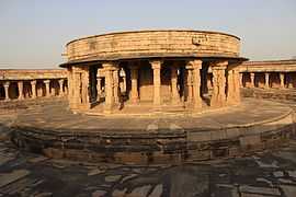
Mitawali :In the north of Naresar, there is a sixty four Yogini temple situated on the hundred feet high mountain. It is a wonderful circular construction of 170 feet radius on the style of Delhi's parliament house. Attached to circular verandah there are sixty four rooms and a big courtyard in the temple. In the centre of the temple there is the circular temple of Lord Shiva and Lord Anuranjan.
Sabalgarh Fort : Amongst the monuments of the medieval age the fort of Sabalgarh is worth visiting. The beautiful ‘Bandh’ built behind the fort in the Scindia period has made the whole scene most fascinating. The foundation of Sabalgarh was laid by a ‘Gujar’ named Sabla in the past. Construction of the fort on a somewhat high cliff was made by Gopal Singh, the Raja of Karoli. Sikandar Lodhi sent a big army to hold control over this strongly built fort. The Marathas in their campaign of northern India again won it and gave it back to the king of Karoli. But in the year 1795 A.D. it was again snatched away from him by Khande Rao whose big house still stands there. During the regime of Lord Vallejali Daulat Rao Scindia (1764-1837) lived in this fort of Gwalior. It was seized by the English in the year 1804-5. In 1809 the area around this fort was added in the kingdom of Scindia.
- sersaini Fort: 35km in west from distt HQ of Morena.Near Bank of Chambal River, Here well established Sati Mata Mandir of Sikarwarsurya Vansi clan. Rao Dalkoo Sikarwar ruled over the Sersaini state in 1494 sambad and declare king of sersaini state in 1494 vikram sambad.He defeated to Meena-Rawat king in battle of sersaini on holi parwa day in 1494 Vikram sambad.
- This fort was built before 1000 ce. Behind of sersaini fort, a Sati Mata Mandir of Sikarwar surya Vansi clan was established by sikarwar clan in 1984 CE. Rao Dalkoo Sikarwar ruled over the Sersaini state with capital sersaini in from 1494 vikrami sambad to ? and He was self declare king of sersaini state on victorious in "battle of sersaini"by defeated to Meena-Rawat king on holi parwa day in 1494 Vikram sambad.chambal river is flowing behind the sersaini fort.It is in ruine condition.None people living on fort in present day.only one village Bersaini near fort is situate.Here Sikarwar kshtriya and Mallah are living at present.NO Bus route here.only reach here by foot or motor cycles/cycles.
Gallery
- Chausath Yogini Temple, Morena
-
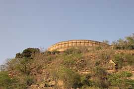
Chausath Yogini Temple, on a hill
-
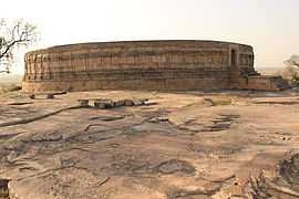
Chausath Yogini Temple, circular in plan like other Yogini temples
-
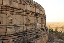
Outer facade has recesses and projections with small rathas and deities carved into them
-
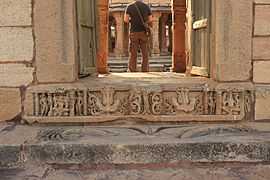
Door jamb
-
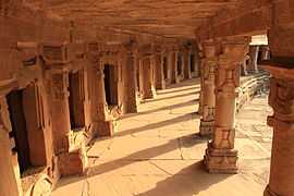
Inner corridor with subsidiary shrines of Shiva Lingams
-
Sanctorum with the Yogini Idol inside
References
- ↑ http://planningcommission.nic.in/reports/sereport/ser/bndel/stdy_bndel.pdf
- ↑ "Delimitation of Parliamentary and Assembly Constituencies Order, 2008" (PDF). The Election Commission of India. pp. 226, 250.
- ↑ 3.0 3.1 3.2 3.3 3.4 3.5 "District Census 2011". Census2011.co.in. 2011. Retrieved 2011-09-30.
- ↑ US Directorate of Intelligence. "Country Comparison:Population". Retrieved 2011-10-01.
Lesotho 1,924,886
- ↑ "2010 Resident Population Data". U. S. Census Bureau. Retrieved 2011-09-30.
New Mexico - 2,059,179
External links
 |
Karauli district, Rajasthan | Dholpur district, Rajasthan | Agra district, Uttar Pradesh | |
| |
Bhind district | |||
| ||||
| | ||||
| Sheopur district | Gwalior district |
| ||||||||||||||||||||||||||
| ||||||||||||||||||||||