Morea

The Morea (Greek: Μωρέας or Μωριάς, French: Morée, Italian: Morea, Turkish: Mora) was the name of the Peloponnese peninsula in southern Greece during the Middle Ages and the early modern period. It also referred to a Byzantine province in the region, known as the Despotate of Morea.
Origins of the name
There is some uncertainty over the origin of the medieval name "Morea", which is first recorded only in the 10th century in the Byzantine chronicles.
Traditionally scholars thought the name originated from the word morea (μορέα), meaning morus or mulberry,[1] a tree which, though known in the region from the ancient times, gained value after the 6th century, when silkworms were smuggled from China to Byzantium. Then the mulberry began to be planted so copiously in the Peloponnesus that the plain around Thebes came to be known as Morokampos and Thebes gained renown for its silk.[2] No silk is now made at Thebes and mulberry trees are not prominent, but the Theban plain retains its name Morokampos from the mulberry trees which once gave the town its prosperity.[3]
The British Byzantinist Steven Runciman suggested that the name comes "from the likeness of its shape to that of a mulberry leaf." [4]
Jakob Philipp Fallmerayer's alternative proposal[5] is that the name comes from the Slavic word more (море, in cyrillic alphabet), meaning "sea". The word for "sea" is море in Serbian, Bulgarian, Russian, and Macedonian; more in Croatian, Slovak, and Bosnian; moře in Czech; morje in Slovenian; mare in Latin, Italian, and Romanian; mar in Spanish and mer in French. It might be supposed that the peninsula, being nearly surrounded by seas, came to be called (the) Morea in early medieval times simply on account of that geographical fact.
History
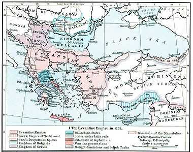
After the conquest of Constantinople by the forces of the Fourth Crusade (1204), two groups of Franks undertook the occupation of the Morea. They created the Principality of Achaea, a largely Greek-inhabited statelet ruled by a Latin (Western) autocrat. In referring to the Peloponnese, they followed local practice and used the name "Morea".
The most important prince in the Morea was Guillaume II de Villehardouin (1246–1278), who fortified Mistra (Mystras) near the site of Sparta in 1249. After losing the Battle of Pelagonia (1259) against the Byzantine Emperor Michael VIII Palaeologus, Guillaume was forced to ransom himself by giving up most of the eastern part of Morea and his newly built strongholds. An initial Byzantine drive to reconquer the entire peninsula failed in the battles of Prinitza and Makryplagi, and the Byzantines and Franks settled to an uneasy coexistence.
In the mid-14th century, the later Byzantine Emperor John VI Kantakouzenos reorganized Morea into the Despotate of the Morea. Sons of the emperor with the rank of despotes were usually sent to rule the province as an appanage. By 1430, the Byzantines eventually recovered the remainder of the Frankish part of the Morea, but in 1460 the peninsula was almost completely overrun and conquered by the Ottoman Empire. In July 1461 the last holdout, Salmeniko Castle, was taken.[6][7][8][9][10][11]
The peninsula was captured for the Republic of Venice by Francesco Morosini during the Morean War of 1684–99. Venetian rule proved unpopular, and the Ottomans recaptured the Morea in a lightning campaign in 1714. Under renewed Ottoman rule, centered at Tripolitsa, the region enjoyed relative prosperity. The latter 18th century was marked by renewed dissatisfaction. Armed bands of the klephts emerged, undeterred by the brutal repression of the Orlov Revolt. They waged guerrilla war against the Turks, aided both by the decay of Ottoman power and the emergence of Greek national consciousness. Ultimately, the Morea and its inhabitants provided the cradle and backbone of the Greek Revolution.
Chronicle of the Morea
The anonymous 14th century Chronicle of the Morea relates events of the Franks' establishment of feudalism in mainland Greece following the Fourth Crusade. Despite its unreliability about historical events, the Chronicle is famous for its lively portrayal of life in the feudal community. The language in Greek versions is notable as it reflects the rapid transition from Medieval to Modern Greek. The original language of the Chronicle is disputed, but recent scholarship prefers the Greek version in MS Havniensis 57 (14th–15th century, in Copenhagen). Other manuscripts include the Ms Parisinus graecus 2898 (15th–16th century, at the Bibliothèque nationale de France, Paris). The difference of about one century in the texts shows a considerable number of linguistic differences due to the rapid evolution of the Greek language.
See also
- List of traditional Greek place names
References
- ↑ "Henry George Liddell, Robert Scott, A Greek-English Lexicon, μορέα". Perseus.tufts.edu. Retrieved 2013-12-03.
- ↑ H.C. Darby, "The face of Europe on the eve of the great discoveries", in The New Cambridge Modern History vol. 1, 1957:34.
- ↑ W.A. Heurtley, H.C. Darby, C W. Crawley, A Short History of Greece from Early Times to 1964 1967:49.
- ↑ Runciman, A Traveller's Alphabet, "Morea")
- ↑ Fallmerayer, Geschichte der Halbinsel Morea während des Mittelalters, Stuttgart, 1825-30.
- ↑ "Monemvasia". Monemvasia. 1941-04-28. Retrieved 2013-12-03.
- ↑ "Monemvasia Lakonia Peloponnese Greece. The travel and holidays guide to Monemvassia in Laconia. Sparti, Gytheio, Mystras, Mani, Elafonissos, Gytheio. Travel greece". Thegreektravel.com. 2013-08-26. Retrieved 2013-12-03.
- ↑ "Welcome to our homepage". Katsoulakos.com. Retrieved 2013-12-03.
- ↑
- ↑ "Genealogy - Geni - private profile - Genealogy". Geni. Retrieved 2013-12-03.
- ↑ "The journal of Hellenic studies". Archive.org. Retrieved 2013-12-03.
Bibliography
- Bon, Antoine (1969). La Morée franque. Recherches historiques, topographiques et archéologiques sur la principauté d’Achaïe (in French). Paris: De Boccard.
- Fine, John Van Antwerp (1994), The Late Medieval Balkans: A Critical Survey from the Late Twelfth Century to the Ottoman Conquest, University of Michigan Press, ISBN 978-0-472-08260-5
- Crusaders as Conquerors: the Chronicle of Morea, translated from the Greek with notes and introduction by Harold E. Lurier, Columbia University, 1964.
- M.J. Jeffreys, "The Chronicle of Morea: Priority of the Greek Version." Byzantinische Zeitschrift 68 (1975), 304-350.
- Teresa Shawcross, The Chronicle of Morea: Historiography in Crusader Greece (Oxford/New York: Oxford University Press, 2009) (Oxford Studies in Byzantium).