Moorea-Maiao
| Moorea-Maiao | ||
|---|---|---|
| ||
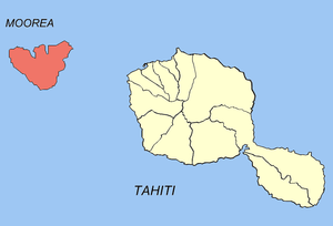
 Location of the commune (in red) within the Windward Islands. The atoll of Maiao lies outside of the map. | ||
| Coordinates: 17°31′35″S 149°49′05″W / 17.5263°S 149.818°WCoordinates: 17°31′35″S 149°49′05″W / 17.5263°S 149.818°W | ||
| Country | France | |
| Overseas collectivity | French Polynesia | |
| Government | ||
| • Mayor | Evans Haumani | |
| Area | 141.8 km2 (54.7 sq mi) | |
| Population (August 2007 census)1 | 16,490 | |
| • Density | 120/km2 (300/sq mi) | |
| INSEE/Postal code | 98729 / 98728 | |
| Elevation | 0–1,207 m (0–3,960 ft) | |
| 1 Population without double counting: residents of multiple communes (e.g., students and military personnel) only counted once. | ||
Moorea-Maiao is a commune of French Polynesia, an overseas territory of France in the Pacific Ocean. The commune is in the administrative subdivision of the Windward Islands.
The commune of Moorea-Maiao is made up of the island of Moorea (133 km²/51 sq. miles; 16,191 inhabitants at the 2007 census) and the much smaller atoll of Maiao (8.8 km²/3.4 sq. miles; 299 inhabitants at the 2007 census),[1] located 78 km (48 mi) southwest of Moorea. The administrative centre of the commune is the settlement of Afareaitu, on the island of Moorea.
References
- ↑ Institut Statistique de Polynésie Française (ISPF). "TABLEAU II Population des communes et communes associées de Polynésie française" (PDF) (in French). Archived from the original (PDF) on 2008-02-29. Retrieved 2007-12-02.
| Wikimedia Commons has media related to Moorea-Maiao. |
