Montverdun
| Montverdun | ||
|---|---|---|
|
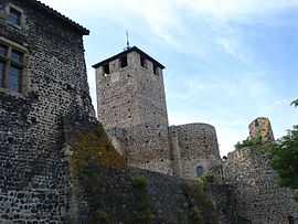
The church and ramparts in Montverdun | ||
| ||
 Montverdun | ||
|
Location within Rhône-Alpes region  Montverdun | ||
| Coordinates: 45°42′56″N 4°04′04″E / 45.7156°N 4.0678°ECoordinates: 45°42′56″N 4°04′04″E / 45.7156°N 4.0678°E | ||
| Country | France | |
| Region | Rhône-Alpes | |
| Department | Loire | |
| Arrondissement | Montbrison | |
| Canton | Boën-sur-Lignon | |
| Intercommunality | Communauté de communes du Pays d'Astrée | |
| Government | ||
| • Mayor (2001–2008) | Pierre Rochette | |
| Area1 | 16.52 km2 (6.38 sq mi) | |
| Population (1999)2 | 759 | |
| • Density | 46/km2 (120/sq mi) | |
| INSEE/Postal code | 42150 / 42130 | |
| Elevation |
340–531 m (1,115–1,742 ft) (avg. 378 m or 1,240 ft) | |
|
1 French Land Register data, which excludes lakes, ponds, glaciers > 1 km² (0.386 sq mi or 247 acres) and river estuaries. 2 Population without double counting: residents of multiple communes (e.g., students and military personnel) only counted once. | ||
.svg.png)
Montverdun is a commune in the Loire department in central France.
Geography
The river Lignon du Forez flows through the commune.
See also
| Wikimedia Commons has media related to Montverdun. |