Montour Falls, New York
| Montour Falls, New York | |
|---|---|
| Village | |
|
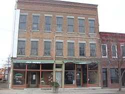
Downtown Montour Falls | |
 Montour Falls, New York Location within the state of New York | |
| Coordinates: 42°20′57″N 76°50′47″W / 42.34917°N 76.84639°WCoordinates: 42°20′57″N 76°50′47″W / 42.34917°N 76.84639°W | |
| Country | United States |
| State | New York |
| County | Schuyler |
| Area | |
| • Total | 3.0 sq mi (7.8 km2) |
| • Land | 3.0 sq mi (7.8 km2) |
| • Water | 0.0 sq mi (0.1 km2) |
| Elevation | 449 ft (137 m) |
| Population (2000) | |
| • Total | 1,797 |
| • Density | 597.7/sq mi (230.8/km2) |
| Time zone | Eastern (EST) (UTC-5) |
| • Summer (DST) | EDT (UTC-4) |
| ZIP code | 14865 |
| Area code(s) | 607 |
| FIPS code | 36-48197 |
| GNIS feature ID | 0974235 |
Montour Falls is a village in Schuyler County, New York, United States. The population was 1,797 at the 2000 census. A waterfall in the village gives the village its name. The name "Montour" is derived from Queen Catharine Montour, a prominent woman of the Seneca who lived in the previous village at this site in the 18th century, before it was destroyed in the Revolutionary War.[1]
The Village of Montour Falls is mostly within the Town of Montour, but a small part is within the Town of Dix. The village is north of Elmira, New York. The New York Academy of Fire Science is located in the village.
History
The village was developed on the site of a former Seneca village, Queanettquaga, informally known as Catherine's Town after a prominent Seneca resident, Catherine Montour. Queanettquaga was destroyed by the retaliatory Sullivan Expedition of 1779 during the American Revolutionary War, which was directed against Iroquois villages of tribes that were allies of Great Britain.
By 1788, as this site began to be settled by European Americans after the war, the village was named Havana. As Havana, this village was designated as the first county seat of Schuyler County. The village was incorporated in 1836. Completed in 1833, the Chemung Canal was built through the village to connect the Chemung River and its watershed to Seneca Lake. At the north end of the lake, another canal connected to the Erie Canal, leading both to the Great Lakes and to the Hudson River and port of New York City, to increase trade and commerce in the region.
In 1861 the county seat was moved to Watkins Glen. The current name of Montour Falls was adopted for the village in 1890. The Town of Montour was also named for Catharine Montour.
The main natural attraction is a 150' waterfall located on the west side of the village. At the base of the falls is a sign labeled "She-qua-ga", a transliteration of its Seneca name. A bridge above the waterfall spells the name as "Che-qua-ga". Many historic names have been recorded under a wide variety of spellings, especially as various peoples tried to transliterate them from one language to another. This attraction is also known as "Montour Falls".
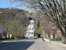
The Brick Tavern Stand and Montour Falls Historic District are listed on the National Register of Historic Places.[2]
Geography
Montour Falls is located at 42°20′57″N 76°50′47″W / 42.34917°N 76.84639°W (42.349209, -76.846450).[3]
According to the United States Census Bureau, the village has a total area of 3.0 square miles (7.8 km2), of which, 3.0 square miles (7.8 km2) of it is land and 0.04 square miles (0.10 km2) of it (0.66%) is water. Catharine Creek flows northward through the Catharine Creek Valley toward Seneca Lake.
New York State Route 14 intersects New York State Route 224 in Montour Falls.
Demographics
As of the census[4] of 2000, there were 1,797 people, 701 households, and 419 families residing in the village. The population density was 597.7 people per square mile (230.5/km²). There were 755 housing units at an average density of 251.1 per square mile (96.8/km²). The racial makeup of the village was 97.61% White, 1.00% African American, 0.33% Native American, 0.22% Asian, 0.17% Pacific Islander, and 0.67% from two or more races. Hispanic or Latino of any race were 0.39% of the population.
There were 701 households out of which 26.1% had children under the age of 18 living with them, 42.2% were married couples living together, 12.7% had a female householder with no husband present, and 40.1% were non-families. 33.0% of all households were made up of individuals and 20.7% had someone living alone who was 65 years of age or older. The average household size was 2.22 and the average family size was 2.79.
In the village the population was spread out with 19.1% under the age of 18, 7.6% from 18 to 24, 23.9% from 25 to 44, 21.6% from 45 to 64, and 27.7% who were 65 years of age or older. The median age was 44 years. For every 100 females there were 77.9 males. For every 100 females age 18 and over, there were 70.1 males.
The median income for a household in the village was $29,018, and the median income for a family was $36,307. Males had a median income of $31,064 versus $21,813 for females. The per capita income for the village was $15,671. About 11.5% of families and 15.3% of the population were below the poverty line, including 24.0% of those under age 18 and 7.4% of those age 65 or over.
Notable people
- William Terry Jackson, former US Congressman
See also
- History of Cornell University - including excerpts on the history of People's College in Havana (now Montour Falls), New York's first land-grant college under the Morrill Acts.
References
- ↑ Tompkins, Andrew E. (n.d.), "Queen Catharine Montour," Schuyler County Historical Society. Accessed: October 15, 2012.
- ↑ "National Register Information System". National Register of Historic Places. National Park Service. 2009-03-13.
- ↑ "US Gazetteer files: 2010, 2000, and 1990". United States Census Bureau. 2011-02-12. Retrieved 2011-04-23.
- ↑ "American FactFinder". United States Census Bureau. Retrieved 2008-01-31.
External links
| Wikimedia Commons has media related to Montour Falls, New York. |
- Village of Montour Falls, NY
- Brief history of Montour Falls
- Academy of Fire Science
- Schuyler Country Historical Society, Montour Falls
| |||||||||||||||||
