Montferland
| Montferland | |||
|---|---|---|---|
| Municipality | |||
|
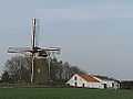
Countryside in Montferland | |||
| |||
.svg.png) Location in Gelderland | |||
| Coordinates: 51°56′N 6°8′E / 51.933°N 6.133°ECoordinates: 51°56′N 6°8′E / 51.933°N 6.133°E | |||
| Country | Netherlands | ||
| Province | Gelderland | ||
| Established | 1 January 2005[1] | ||
| Government[2] | |||
| • Body | Municipal council | ||
| • Mayor | Ina Leppink-Schuitema (VVD) | ||
| Area[3] | |||
| • Total | 106.63 km2 (41.17 sq mi) | ||
| • Land | 105.68 km2 (40.80 sq mi) | ||
| • Water | 0.95 km2 (0.37 sq mi) | ||
| Elevation[4] | 13 m (43 ft) | ||
| Population (May 2014)[5] | |||
| • Total | 35,059 | ||
| • Density | 332/km2 (860/sq mi) | ||
| Time zone | CET (UTC+1) | ||
| • Summer (DST) | CEST (UTC+2) | ||
| Postcode | 6940–6942, 7035–7048 | ||
| Area code | 0314, 0316 | ||
| Website |
www | ||


Montferland (![]() pronunciation ) is a municipality in Gelderland, the Netherlands. It was created on 1 January 2005 from the former municipalities of Bergh and Didam.
pronunciation ) is a municipality in Gelderland, the Netherlands. It was created on 1 January 2005 from the former municipalities of Bergh and Didam.
Population centres
Formerly from Bergh:
- 's-Heerenberg
- Stokkum
- Zeddam
- Braamt
- Kilder
- Lengel
- Loerbeek
- Beek
- Azewijn
- Vethuizen
- Wijnbergen
Formerly from Didam:
- Didam
- Greffelkamp
- Holthuizen
- Loil
- Nieuw-Dijk
- Oud-Dijk
Loil
Loil is a village with a population of about 1,500 people. Located next to Didam and Nieuw-Dijk, it is part of the new municipality Montferland. Loil is known for its big celebration of carnival (second biggest parade in the Netherlands). Loil has an active social life, with a lot of sports clubs like football, volleyball (s.v. Loil, established in 1956). It also has a music organization Amicitia, established in 1913, and a shooting club Schutterij Loil-Vooruit. The village has a windmill, a Roman Catholic parish church and an elementary school, named after Saint Joseph.
The first time Loil was mentioned in official papers was in 1178, although the name was Loel back then. Loil consists of mostly farmerland in a rural area.
Gallery
-
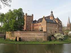
's-Heerenberg, castle: huize Bergh
-
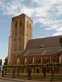
Didam, church
-
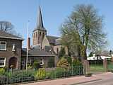
Beek, church: Sint Martinuskerk
-
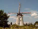
Zeddam, windmill in the village
-
Stokkum, windmill: Düffels Möl
-

Kilder, church
References
- ↑ "Gemeentelijke indeling op 1 januari 2005" [Municipal divisions on 1 January 2005]. cbs.nl (in Dutch). CBS. Retrieved 10 July 2014.
- ↑ "Samenstelling college" [Members of the board] (in Dutch). Gemeente Montferland. Retrieved 10 July 2014.
- ↑ "Kerncijfers wijken en buurten" [Key figures for neighbourhoods]. CBS Statline (in Dutch). CBS. 2 July 2013. Retrieved 12 March 2014.
- ↑ "Postcodetool for 6942GK". Actueel Hoogtebestand Nederland (in Dutch). Het Waterschapshuis. Retrieved 10 July 2014.
- ↑ "Bevolkingsontwikkeling; regio per maand" [Population growth; regions per month]. CBS Statline (in Dutch). CBS. 26 June 2014. Retrieved 24 July 2014.
External links
 Media related to Montferland at Wikimedia Commons
- Official website
 |
Doetinchem | | ||
| Zevenaar | |
Oude IJsselstreek | ||
| ||||
| | ||||
| Emmerich am Rhein (DE-NW) |
