Montes Rook
| Montes Rook | |
|---|---|
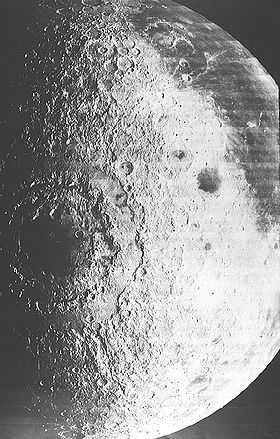 1967 photograph of the Mare Orientale impact basin made by NASA's Lunar Orbiter 4 | |
| Listing | Lunar mountains |
| Location | |
| Location | the Moon |
| Coordinates | 20°36′S 82°30′W / 20.6°S 82.5°W |
Montes Rook is a ring-shaped mountain range that lies along the western limb of the Moon, crossing over to the far side. It completely encircles the Mare Orientale, and forms part of a massive impact basin feature. This range in turn is encircled by the larger Montes Cordillera, which is separated from the Montes Rook by a rugged, ring-shaped plain.
The Montes Rook is actually a double-ring formation, sometimes divided into the outer Rook and the inner Rook. Sections of the gap between these sub-ranges contain long valleys filled in places with basaltic lava, forming small lunar maria. One such section along the northeastern part of the range has been named Lacus Veris.
The selenographic coordinates of this range are 20.6° S, 82.5° W, and the diameter is 791 km. The range was named after the English astronomer Lawrence Rook. Due to its location this range is viewed from the edge from Earth, and not much detail can be seen. However a partial view of the range can be obtained by projecting the surface of a globe. This rectified map was used to identify the Mare Orientale impact basin.
Several named craters are embedded within the Montes Rook. Near the southwest outer edge are the craters Nicholson and Pettit. Kopff lies along the eastern inner edge, and Maunder on the northern inner side. Smaller craters include Lallemand to the northeast, Shuleykin to the south, and Fryxell in the west. Out of sight from the Earth, even during favorable librations, are the craters Lowell to the northwest, and Golitsyn to the west-southwest.