Montemonaco
| Montemonaco | ||
|---|---|---|
| Comune | ||
| Comune di Montemonaco | ||
|
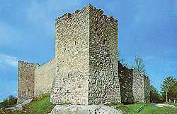
Torrioni on Montemonaco walls | ||
| ||
 Montemonaco Location of Montemonaco in Italy | ||
| Coordinates: 42°54′N 13°20′E / 42.900°N 13.333°ECoordinates: 42°54′N 13°20′E / 42.900°N 13.333°E | ||
| Country | Italy | |
| Region | Marche | |
| Province | Ascoli Piceno (AP) | |
| Frazioni | Altino, Ariconi, Cerqueto, Cese, Cittadella, Colleregnone, Collina, Ferrà, Foce, Isola San Biagio, Lanciatoio, Le Castagne, Le Vigne, Pescolle, Pignotti, Poggio di pietra, Rascio, Rivo Rosso, Rocca, Rocca da capo, Ropaga, San Giorgio all'Isola, San Lorenzo, Tofe, Vallefiume, Vallegrascia. | |
| Government | ||
| • Mayor | Onorato Corbelli | |
| Area | ||
| • Total | 67.52 km2 (26.07 sq mi) | |
| Elevation | 980 m (3,220 ft) | |
| Population (28 February 2010)[1] | ||
| • Total | 658 | |
| • Density | 9.7/km2 (25/sq mi) | |
| Demonym | Montemonachesi | |
| Time zone | CET (UTC+1) | |
| • Summer (DST) | CEST (UTC+2) | |
| Postal code | 63048 | |
| Dialing code | 0736 | |
| Patron saint | St. Sebastian | |
| Saint day | January 20 | |
Montemonaco is a town and comune (municipality) in the Province of Ascoli Piceno in the Italian region Marche, located about 90 kilometres (56 mi) south of Ancona and about 20 kilometres (12 mi) northwest of Ascoli Piceno. It is located within the Parco Nazionale dei Monti Sibillini, along the valley of the Aso River, on a plateau facing the Monte Zampa and the Monte Sibilla. In the nearby are also the Monte Vettore and the Lago di Pilato.
Montemonaco borders the following municipalities: Arquata del Tronto, Castelsantangelo sul Nera, Comunanza, Montefortino, Montegallo, Norcia. It takes its name from a Benedictines' monastery founded here around the 8th century.