Montegallo
| Montegallo | |
|---|---|
| Comune | |
| Comune di Montegallo | |
 Montegallo Location of Montegallo in Italy | |
| Coordinates: 42°50′N 13°20′E / 42.833°N 13.333°ECoordinates: 42°50′N 13°20′E / 42.833°N 13.333°E | |
| Country | Italy |
| Region | Marche |
| Province | Province of Ascoli Piceno (AP) |
| Frazioni | Abetito, Astorara, Balzo, Balzetto, Bisignano, Castro, Colle, Collefratte, Colleluce, Collicello, Corbara, Fonditore, Forca, Interprete, Migliarelli, Piano, Propezzano, Rigo, Uscerno, Vallorsara |
| Area | |
| • Total | 48.6 km2 (18.8 sq mi) |
| Population (Dec. 2004) | |
| • Total | 603 |
| • Density | 12/km2 (32/sq mi) |
| Demonym | Montegallesi |
| Time zone | CET (UTC+1) |
| • Summer (DST) | CEST (UTC+2) |
| Postal code | 63040 |
| Dialing code | 0736 |
| Website | Official website |
Montegallo is a comune (municipality) in the Province of Ascoli Piceno in the Italian region Marche, located about 90 kilometres (56 mi) south of Ancona and about 20 kilometres (12 mi) west of Ascoli Piceno. As of 31 December 2004, it had a population of 603 and an area of 48.6 square kilometres (18.8 sq mi).[1]
The municipality of Montegallo contains the frazioni (subdivisions, mainly villages and hamlets) Abetito, Astorara, Balzo, Balzetto, Bisignano, Castro, Colle, Collefratte, Colleluce, Collicello, Corbara, Fonditore, Forca, Interprete, Migliarelli, Piano, Propezzano, Rigo, Uscerno, and Vallorsara.
Montegallo borders the following municipalities: Acquasanta Terme, Arquata del Tronto, Comunanza, Montemonaco, Roccafluvione.
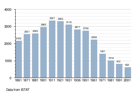
Demographic evolution