Monte Perdido
| Monte Perdido | |
|---|---|
|
Monte Perdido (left) and Cilindro de Marboré (right) | |
| Elevation | 3,355 m (11,007 ft) |
| Translation | Lost mountain (Spanish) |
| Location | |
 Monte Perdido Pyrenees | |
| Location | Ordesa Valley, Huesca Province, Aragon, Spain |
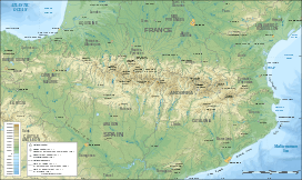
| Range | Pyrenees |
| Coordinates | 42°40′N 0°02′E / 42.667°N 0.033°ECoordinates: 42°40′N 0°02′E / 42.667°N 0.033°E |
| Official name | Pyrénées - Mont Perdu |
| Type | Mixed |
| Criteria | iii, iv, v, vii, viii |
| Designated | 1997 (21st session) |
| Reference no. | 773 |
| State Party | Spain |
| Region | Europe and North America |
| Extensions | 1999 |
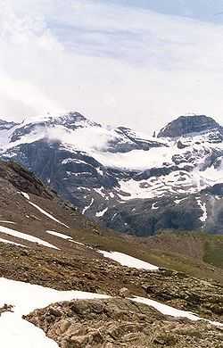

Monte Perdido (in Spanish; Mont Perdu in French; Mont Perdito in Aragonese, all three meaning lost mountain) is the third highest mountain in the Pyrenees. The summit of Monte Perdido (3355 m), located in Spain, lies hidden from France by the seemingly impenetrable peaks of the Cirques of Gavarnie and Estaubé. It is in the north of Huesca province. The mountain forms part of the Monte Perdido Range and is located in Ordesa y Monte Perdido National Park, in the western part of the Pyrenees, in the community of Aragon, Spain.
Access to the mountain is easier from Spain than from France. The route starts near the village of Torla, Aragon, at the Ordesa Valley and ascends the Cirque de Soaso towards the Refuge of Góriz before the stiff climb to the summit. It is a dangerous climb with snow.
National Park
Monte Perdido is the centre-piece of the Spanish Ordesa y Monte Perdido National Park which was established in 1918 with just 21 square kilometres of land. The park has grown significantly to 156 square kilometres and incorporates the whole of the Añisclo Canyon. There are more than 1500 species of flowers, 171 species of birds, 32 different mammals and 8 types of reptile in the Ordesa. Most magnificent of all is the lammergeier (bearded vulture) with a 3 metre wingspan. The Pyrenees is one of the few places in Europe where these birds can be seen.
See also
External links
- (Spanish) Normal route and Escaleras route to climb Monte Perdido komandokroketa.org, retrieved 2013-08-20
- (English) "Glaciar de Monte Perdido - Gavarnie and Monte Perdido Massif" swisseduc.ch, retrieved 2013-08-20
| ||||||||||||||||||||||||||||||||||||||||||