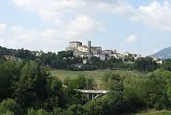
Monte Cerignone
| Monte Cerignone | ||
|---|---|---|
| Comune | ||
| Comune di Monte Cerignone | ||
 | ||
| ||
 Monte Cerignone Location of Monte Cerignone in Italy | ||
| Coordinates: 43°50′N 12°25′E / 43.833°N 12.417°E | ||
| Country | Italy | |
| Region | Marche | |
| Province | Pesaro e Urbino (PU) | |
| Frazioni | Valle di Teva | |
| Government | ||
| • Mayor | Davide Giorgio Giorgini | |
| Area | ||
| • Total | 18.1 km2 (7.0 sq mi) | |
| Elevation | 528 m (1,732 ft) | |
| Population (28 February 2010)[1] | ||
| • Total | 675 | |
| • Density | 37/km2 (97/sq mi) | |
| Demonym | Cerignonesi | |
| Time zone | CET (UTC+1) | |
| • Summer (DST) | CEST (UTC+2) | |
| Postal code | 61010 | |
| Dialing code | 0541 | |
| Patron saint | St. Blaise | |
| Saint day | February 3 | |
| Website | Official website | |
Monte Cerignone is a comune (municipality) in the Province of Pesaro e Urbino in the Italian region Marche, located about 90 kilometres (56 mi) northwest of Ancona and about 40 kilometres (25 mi) west of Pesaro.
Monte Cerignone borders the following municipalities: Macerata Feltria, Mercatino Conca, Montecopiolo, Monte Grimano, Sassocorvaro, Tavoleto.
Sights include the Malatesta fortress, which was partly designed by Francesco di Giorgio Martini.