Monte Ceneri Pass
| Monte Ceneri Pass | |
|---|---|
|
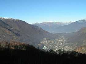
Monte Ceneri Pass looking north | |
| Elevation | 554 m (1,818 ft)[1] |
| Traversed by | Road, rail |
| Location | Ticino, Switzerland |
| Range | Lugano Prealps |
| Coordinates | 46°8′21″N 8°54′24″E / 46.13917°N 8.90667°ECoordinates: 46°8′21″N 8°54′24″E / 46.13917°N 8.90667°E |
 Location in Switzerland | |
Monte Ceneri Pass is a mountain pass in the canton of Ticino in Switzerland. It connects the Magadino plain and the Vedeggio valley across the Lugano Prealps at an elevation of 554 metres (1,818 ft) above sea level. In so doing, it provides the most direct route between the cities of Bellinzona and Lugano.[1]
Two tunnels have been dug under the Monte Ceneri, the Monte Ceneri Road Tunnel for the A2 motorway and the Monte Ceneri Rail Tunnel for the Gotthard railway. A new rail tunnel, the Ceneri Base Tunnel, is currently under construction that will connect Camorino near Bellinzona and Vezia near Lugano.[1][2]
The pass is situated in the municipality of Monteceneri and the district of Lugano. The Monte Ceneri radio transmitter is located close to the pass.[1]
The larger part of Ticino, which lies to the north of the Monte Ceneri Pass and includes the valley of the Ticino river and the cities of Bellinzona and Locarno, is often referred to as the Sopraceneri (above the Ceneri). The smaller part to the south, which includes Lugano, Mendrisio and Chiasso, takes the name Sottoceneri (under the Ceneri).
See also
References
- ↑ 1.0 1.1 1.2 1.3 map.geo.admin.ch (Map). Swiss Confederation. Retrieved 2012-11-21.
- ↑ "Ceneri Base Tunnel: Blast-driving the main tunnel from Sigirino begins". AlpTransit. 10 March 2009. Retrieved 2011-11-12.