Montaigu-le-Blin
| Montaigu-le-Blin | |
|---|---|
|
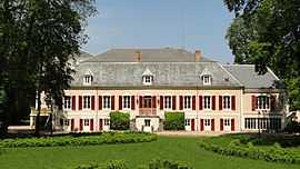
The chateau in Montaigu-le-Blin | |
 Montaigu-le-Blin | |
|
Location within Auvergne region  Montaigu-le-Blin | |
| Coordinates: 46°17′43″N 3°30′43″E / 46.2953°N 3.5119°ECoordinates: 46°17′43″N 3°30′43″E / 46.2953°N 3.5119°E | |
| Country | France |
| Region | Auvergne |
| Department | Allier |
| Arrondissement | Vichy |
| Canton | Varennes-sur-Allier |
| Intercommunality | Varennes Forterre |
| Government | |
| • Mayor (2008–2014) | Christine Martin-Tison |
| Area1 | 12.96 km2 (5.00 sq mi) |
| Population (2008)2 | 306 |
| • Density | 24/km2 (61/sq mi) |
| INSEE/Postal code | 03179 / 03150 |
| Elevation |
263–342 m (863–1,122 ft) (avg. 331 m or 1,086 ft) |
|
1 French Land Register data, which excludes lakes, ponds, glaciers > 1 km² (0.386 sq mi or 247 acres) and river estuaries. 2 Population without double counting: residents of multiple communes (e.g., students and military personnel) only counted once. | |
Montaigu-le-Blin is a commune in the Allier department in central France. It was first mentioned in the 10th century as Monte Acuto.
Population
| Historical population | ||
|---|---|---|
| Year | Pop. | ±% |
| 1962 | 473 | — |
| 1968 | 531 | +12.3% |
| 1975 | 475 | −10.5% |
| 1982 | 425 | −10.5% |
| 1990 | 374 | −12.0% |
| 1999 | 356 | −4.8% |
| 2008 | 306 | −14.0% |
See also
References
| Wikimedia Commons has media related to Montaigu-le-Blin. |