Montagano
| Montagano | |
|---|---|
| Comune | |
| Comune di Montagano | |
 Montagano Location of Montagano in Italy | |
| Coordinates: 41°39′N 14°40′E / 41.650°N 14.667°ECoordinates: 41°39′N 14°40′E / 41.650°N 14.667°E | |
| Country | Italy |
| Region | Molise |
| Province | Province of Campobasso (CB) |
| Government | |
| • Mayor | Enrico Galuppo |
| Area | |
| • Total | 26.5 km2 (10.2 sq mi) |
| Elevation | 803 m (2,635 ft) |
| Population (Dec. 2004) | |
| • Total | 1,207 |
| • Density | 46/km2 (120/sq mi) |
| Demonym | Montaganesi |
| Time zone | CET (UTC+1) |
| • Summer (DST) | CEST (UTC+2) |
| Postal code | 86023 |
| Dialing code | 0874 |
| Patron saint | Sant' Alessandro |
| Website | Official website |
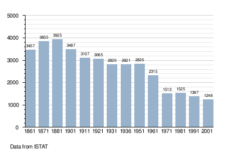
Montagano is a comune (municipality) in the Province of Campobasso in the Italian region Molise, located about 9 kilometres (6 mi) north of Campobasso. Montagano rises on one side of the Biferno river, where once stood an ancient Samnite town where inhabitants in the 4th century B.C. sided with Hannibal against Rome. As of 31 December 2004, it had a population of 1,207 and an area of 26.5 square kilometres (10.2 sq mi).[1]
Montagano is a beautiful and quaint, white stone village surrounded by farmland that borders the following municipalities: Limosano, Matrice, Petrella Tifernina, Ripalimosani.
Demographic evolution