Mont Valier
| Mont Valier | |
|---|---|
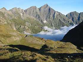 Mont Valier seen from the Port d'Aula | |
| Elevation | 2,838 m (9,311 ft)[1] |
| Location | |
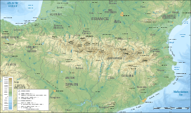 Mont Valier Pyrenees | |
| Location | Ariège, France |
| Range | Pyrenees |
| Coordinates | 42°47′52″N 01°05′08″E / 42.79778°N 1.08556°ECoordinates: 42°47′52″N 01°05′08″E / 42.79778°N 1.08556°E |
| Climbing | |
| Easiest route | By the Ribérot valley and the refuge des Estagnous |
Mont Valier (2,838 m) is a mountain in Ariège in the Pyrenees.
Its name comes from Valerius (Saint Valier, ca. 452), the mythical first bishop of Couserans,[2] who made an ascent of the peak. Bernard de Marmiesse, another bishop of Couserans, had a marble cross erected on the peak in 1670.[3]
Geography
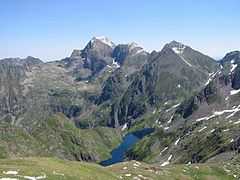
Mont Valier belongs to the Pyrénean axial channel. A small glacier - Glacier d'Arcouzan - occupies its north-eastern slope. It is the only glacier in the Pyrénées situated in a massif below 3000m, the most Eastern glacier in the chain and also the most isolated. The summit is located on the perimeter of the regional park of the Ariège Pyrénées.
A set of valleys originate on its sides:
(on the French side): the stream of Artigues, a tributary of the Salat (which itself rises a few miles from Mount Valier); the Ribérot, a tributary of the Lez, itself a tributary of the Salat.
(on the Spanish side): the Noguera Pallaresa, and a few miles to the west, one of many sources of the Garonne.
Climbing
The normal route climbs from the Refuge des Estagnous to the Col Faustin and then ascends the broad South face. In summer this is little more than a tough and, in a few places, exposed walk. The other principal route to the summit is via the Arête des Antiques (AD-) and involves rock climbing along an exposed ridge. The east face and its famous "Trou Noir", (black hole) first climbed by Louis Audoubert in 1971 and rated TD, is rarely ascended.[4] The classic ascent in winter is via the Couloir Faustin; it is a long outing mostly on snow (AD).
History
During World War II, an escape route from Saint-Girons to Esterri in Catalonia crossed Mont Valier. The "Path to Freedom" – the name given in 1994 to the hiking trail that follows course – enabled the escape of 782 people between 1940 and 1944 and remained operational despite increased surveillance of the Germans from 1943 and denunciations from the French collaborators. The route was operational until the end of the war.
Protected zone
By ministerial decree of 5 July 2005, a large territory centred on the village of Seix, including the crown reserve of Mount Valier – founded in 1937 (and one of the oldest in the Pyrenees ) – and nearly all federal lands of the Fonta massif was classified as a "special protection area" and a site of the Natura 2000 network.
References
- ↑ IGN at 1:25000 scale on Géoportail
- ↑ A. Bourneton, "Une ascension inédite sous le premier Empire", Pyrénées, no. 183-184, 1995, pp. 295-312 ; no. 185, 1996, pp. 16-28 ; no. 186, 1996, pp. 123-133
- ↑ Giles Barber, Saint-Girons - Ses rues, leur histoire à travers les âges, PyréGraph, 2005. ISBN 2-908723-64-6.
- ↑ http://www.explos.info/2011/10/magie-noire-valier/