Mont Thabor
| Mont Thabor | |
|---|---|
 | |
| Elevation | 3,178 m (10,427 ft) |
| Location | |
 Mont Thabor France | |
| Location | Savoie and Hautes-Alpes, France |
| Range | Massif des Cerces |
| Coordinates | 45°06′51″N 06°33′50″E / 45.11417°N 6.56389°ECoordinates: 45°06′51″N 06°33′50″E / 45.11417°N 6.56389°E |
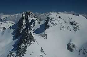
Pic du Thabor on the left, and the Mont Thabor on the right, from the col de Valmenier.
Mont Thabor is a mountain of Savoie and Hautes-Alpes, France. It lies in the Massif des Cerces range. It has an elevation of 3,178 metres above sea level, it stands closed to another summit, the Pic du Thabor, culminating at 3,207 metres above sea level.