Mont Blanc
| Mont Blanc | |
|---|---|
| Monte Bianco | |
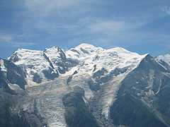
 South face of Mont Blanc / Monte Bianco | |
| Elevation | 4,810 m (15,780 ft) |
| Prominence |
4,696 m (15,407 ft) Ranked 11th |
| Parent peak | Mount Everest |
| Listing |
Country high point Ultra Seven Summits |
| Location | |
 Mont Blanc Location in the Alps | |
| Location |
Aosta Valley, Italy Haute-Savoie, France |
| Range | Graian Alps |
| Coordinates | 45°50′01″N 006°51′54″E / 45.83361°N 6.86500°ECoordinates: 45°50′01″N 006°51′54″E / 45.83361°N 6.86500°E |
| Climbing | |
| First ascent |
8 August 1786 by Jacques Balmat Michel-Gabriel Paccard |
Mont Blanc (French pronunciation: [mɔ̃.blɑ̃]) or Monte Bianco (Italian pronunciation: [ˈmonte ˈbjaŋko]), both meaning "White Mountain", is the highest mountain in the Alps and the highest peak in Europe outside of the Caucasus range.[1] It rises 4,810 m (15,781 ft)[2] above sea level and is ranked 11th in the world in topographic prominence. [3]
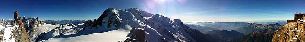
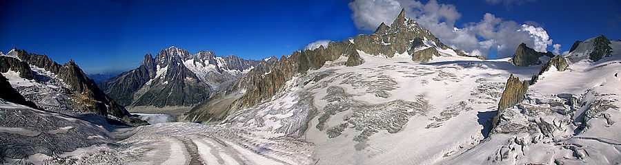
The mountain lies in a range called the Graian Alps, between the regions of Aosta Valley, Italy, and Haute-Savoie, France. The location of the summit is on the watershed line between the valleys of Ferret and Veny in Italy and the valleys of Montjoie and Arve in France. The Mont Blanc massif is popular for mountaineering, hiking, skiing, and snowboarding.
The three towns and their communes which surround Mont Blanc are Courmayeur in Aosta Valley, Italy, and Saint-Gervais-les-Bains and Chamonix in Haute-Savoie, France. The latter town was the site of the first Winter Olympics. A cable car ascends and crosses the mountain range from Courmayeur to Chamonix, through the Col du Géant. Constructed beginning in 1957 and completed in 1965, the 11.6 km (7¼ mi) Mont Blanc Tunnel runs beneath the mountain between these two countries and is one of the major trans-Alpine transport routes.
History

The first recorded ascent of Mont Blanc was on 8 August 1786 by Jacques Balmat and the doctor Michel Paccard. This climb, initiated by Horace-Bénédict de Saussure, who gave a reward for the successful ascent, traditionally marks the start of modern mountaineering.[4] The first woman to reach the summit was Marie Paradis in 1808, and the first dog without human technical help was "Tschingel" from Grindelwald (making his climb before the first female honorary member of the Alpine Club).
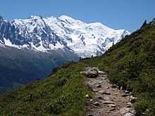
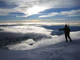
Now the summit is ascended by an average 20,000 mountaineer-tourists each year. It could be considered an easy, yet long, ascent for someone who is well trained and used to the altitude. From l'Aiguille du Midi (where the cable car stops), Mont Blanc seems quite close, being 1,000 m (3,300 ft) higher. But while the peak seems deceptively close, La Voie des 3 Monts route (known to be more technical and challenging than other more commonly used routes) requires much ascent and descent before the final section of the climb is reached and the last 1000 m push to the summit is undertaken.
Each year climbing deaths occur on Mont Blanc, and on the busiest weekends, normally around August, the local rescue service performs an average of 12 missions, mostly directed to aid people in trouble on one of the normal routes of the mountain. Some routes require knowledge of high-altitude mountaineering, a guide (or at least a veteran mountaineer), and proper equipment. It is a long course that includes delicate passages and the hazard of rock slides. Also, at least one night at the refuge is required to acclimatize to the altitude; less could lead to altitude sickness and possible death.[5][6]
Ownership of the summit
Since the French Revolution, the issue of the ownership of the summit has been debated. From 1416 to 1792, the entire mountain was within the Duchy of Savoy. In 1723 the Duke of Savoy, Victor Amadeus II, acquired the Kingdom of Sardinia. The resulting state of Piedmont-Sardinia was to become preeminent in the Italian unification.[8] In September 1792, the French revolutionary Army of the Alps under Anne-Pierre de Montesquiou-Fézensac seized Savoy without much resistance and created a department of the Mont-Blanc. In a treaty of May 15, 1796, Victor Amadeus III of Sardinia was forced to cede Savoy and Nice to France. In article 4 of this treaty it says: "The border between the Sardinian kingdom and the departments of the French Republic will be established on a line determined by the most advanced points on the Piedmont side, of the summits, peaks of mountains and other locations subsequently mentioned, as well as the intermediary peaks, knowing: starting from the point where the borders of Faucigny, the Duchy of Aoust and the Valais, to the extremity of the glaciers or Monts-Maudits: first the peaks or plateaus of the Alps, to the rising edge of the Col-Mayor". This act further states that the border should be visible from the town of Chamonix and Courmayeur. The summit is not visible from the village of Courmayeur, because part of the mountain lower down obscures it, although it is visible from other hamlets within Courmayeur's municipality. The official French maps still portray the border following this concept, putting the summit area entirely in France.

After the Napoleonic Wars, the Congress of Vienna restored the King of Sardinia in Savoy, Nice and Piedmont, his traditional territories, overruling the 1796 Treaty of Paris. Forty-five years later, after the Second Italian War of Independence, it was replaced by a new legal act. This act was signed in Turin on 24 March 1860 by Napoleon III and Victor Emmanuel II of Savoy, and deals with the annexation of Savoy (following the French neutrality for the plebiscites held in Tuscany and Emilia-Romagna to join the Kingdom of Sardinia, against the Pope's will). A demarcation agreement, signed on 7 March 1861, defines the new border. With the formation of Italy, for the first time Mont Blanc is located on the border of France and Italy.
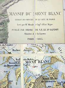
The 1860 act and attached maps are still legally valid for both the French and Italian governments.[10] One of the prints from the 1823 Sarde Atlas[11] positions the border exactly on the summit edge of the mountain (and measures it to be 4,804 m (15,761 ft) high). The convention of 7 March 1861 recognises this through an attached map, taking into consideration the limits of the massif, and drawing the border on the icecap of Mont Blanc, making it both French and Italian. Watershed analysis of modern topographic mapping not only places the main summit on the border, but also suggests that the border should follow a line northwards from the main summit towards Mont Maudit, leaving the southeast ridge to Mont Blanc de Courmayeur wholly within Italy.
Although the Franco-Italian border was redefined in both 1947 and 1963, the commission made up of both Italians and French ignored the Mont Blanc issue. In the early 21st century, administration of the mountain is shared between the Italian town of Courmayeur and the French town of Saint-Gervais-les-Bains, although the larger part of the mountain lies within the commune of the latter.
Vallot cabin
The first professional scientific investigations on the summit were conducted by the botanist-meteorologist Joseph Vallot at the end of the 19th century. He wanted to stay near the top of the summit, so he built his own permanent cabin.
Janssen observatory
In 1890, Pierre Janssen, an astronomer and the director of the Meudon astrophysical observatory, considered the construction of an observatory at the summit of Mont Blanc. Gustave Eiffel agreed to take on the project, provided he could build on a rock foundation, if found at a depth of less than 12 m (39 ft) below the ice. In 1891, the Swiss surveyor Imfeld dug two 23 m (75 ft) long horizontal tunnels 12 m (39 ft) below the ice summit but found nothing solid. Consequently, the Eiffel project was abandoned.
Despite this, the observatory was built in 1893. During the cold wave of January 1893 a temperature of −43 °C (−45 °F) was recorded on Mont Blanc, being the lowest ever recorded there.
Levers attached to the ice supported the observatory. This worked to some extent until 1906, when the building started leaning heavily. The movement of the levers corrected the lean slightly, but three years later (two years after Janssen’s death), a crevasse started opening under the observatory. It was abandoned. Eventually the building fell, and only the tower could be saved in extremis.[12]
Air crashes
The mountain was the scene of two fatal air crashes; Air India Flight 245 in 1950 [13] and Air India Flight 101 in 1966. Both planes were approaching Geneva airport and the pilots miscalculated their descent; 48 and 117 people, respectively, died.[14] The latter passengers included top nuclear scientist Homi J. Bhabha, known as the "father" of India's nuclear programme.[15]
Tunnel
In 1946 a drilling project was initiated to carve a tunnel through the mountain. The Mont Blanc tunnel would connect Chamonix, France and Courmayeur, Italy and become one of the major trans-Alpine transport routes between the two countries. In 1965 the tunnel opened to vehicle traffic with a length of 11,611 metres (7.215 mi).[16]
1999 disaster
In 1999 a transport truck caught fire in the tunnel beneath the mountain. In total 39 people were killed when the fire raged out of control. The tunnel was renovated in the aftermath to increase driver safety , reopening after 3 years.[17]
Elevation
The summit of Mont Blanc is a thick, perennial ice and snow dome whose thickness varies. No exact and permanent summit elevation can therefore be determined, though accurate measurements have been made on specific dates. For a long time its official elevation was 4,807 m (15,771 ft). In 2002, the IGN and expert surveyors, with the aid of GPS technology, measured it to be 4,810.40 m (15,782 ft 2 in).
After the 2003 heatwave in Europe, a team of scientists re-measured the height on 6 and 7 September. The team was made up of the glaciologist Luc Moreau, two surveyors from the GPS Company, three people from the IGN, seven expert surveyors, four mountain guides from Chamonix and Saint-Gervais and four students from various institutes in France. This team noted that the elevation was 4,808.45 m (15,775 ft 9 in), and the peak was 75 centimetres (30 in) away from where it had been in 2002.
After these results were published, more than 500 points were measured, to assess the effects of climate change and the fluctuations in the height of the mountain at different points. Since then, the elevation of the mountain has been measured every two years.
The interpretation that the heatwave had caused this fluctuation is disputed because the heatwave is known not to have significantly affected the glaciers above 4,000 m (13,000 ft). The height and position of the summit could have been moved by general glacial forces. At this elevation, the temperatures rarely rise above 0 °C (32 °F). During the summer of 2003, the temperature rose to 2 °C (36 °F), and even 3 °C (37 °F), but this would not have been enough for the ice to melt that amount.
The summit was measured again in 2005, and the results were published on 16 December 2005. The height was found to be 4,808.75 m (15,776 ft 9 in), 30 cm (12 in) more than the previous recorded height. The rock summit was found to be at 4,792 m (15,722 ft), some 40 m (130 ft) west the ice-covered summit.[18]
In 2007 the summit was measured at 4,810.9 m (15,784 ft) and in 2009 at 4,810.45 m (15,782 ft).[2]
Climbing routes
Blanc Massif averages nearly 100 fatalities a year. A published estimate suggests there have been 6,000-8,000 alpinist fatalities in total. (The High Mountains of the Alps, Dumler, 1994). Several classic climbing routes lead to the summit of Mont Blanc:[19]
- The most popular route is the Voie Des Cristalliers, also known as the Voie Royale. Starting from Saint-Gervais-les-Bains, the Tramway du Mont-Blanc (TMB) is taken to get to the Nid d'Aigle. The ascent begins in the direction of the Refuge de Tête Rousse and through the Goûter Corridor,[20] considered dangerous because of frequent rock-falls, leading to Goûter cabin for night shelter. The next day the route leads to the Dôme du Goûter, the Vallot cabin and L'arrête des Bosses.
- La Voie des 3 Monts is also known as La Traversée. Starting from Chamonix, the Téléphérique de l'Aiguille du Midi is taken towards the Col du Midi. The Cosmiques cabin is used to spend the night. The next day the ascent continues through Mont Blanc du Tacul and Mont Maudit. In 2014 the remains were found of a climber who had gone missing in 1982.[21]
- The historic itinerary through the Grand Mulets, which is most frequently traversed in winter by ski or in summer, to descend to Chamonix.
- The normal Italian itinerary is also known as La route des Aiguilles Grises. After crossing the Miage Glacier, climbers spend the night at the Gonella refuge. The next day one proceeds through the Col des Aiguilles Grises and the Dôme du Goûter, concluding at L'arête des Bosses.
- The Miage — Bionnassay — Mont Blanc crossing is usually done in three days. The route begins from Contamines-Montjoie, with the night spent in the Conscrits cabin. The following day, the Dômes de Miages is crossed and the night spent at the Durier cabin. The third day proceeds through l'Aiguille de Bionnassay and then the Dôme du Goûter.
From the summit of Mont Blanc on a clear day, the Jura, the Vosges, the Black Forest and the Massif Central mountain ranges can be seen, as well as the principal summits of the Alps.
Exploits and incidents
- 1786 – The first ascent, by Michel-Gabriel Paccard and Jacques Balmat; see Exploration of the High Alps.
- 1787 – The fourth ascent, by Englishman Mark Beaufoy, with at least six guides and a servant.
- July 1808 – The first ascent by a woman, Maria Paradis, with Balmat as her guide.
- July 1838 – The second ascent by a woman, Henriette d'Angeville.
- 1886 – Future U.S. President Theodore Roosevelt had led an expedition to the peak.
- 1890 – Giovenni Bonin, Luigi Grasselli and Fr. Achille Ratti (later Pope Pius XI) discovered the normal Italian route (West Face Direct) on descent.
- 1960 – The airplane pilot Henri Giraud landed on the summit, which is only 30 m (98 ft) long.[22]
- 1990 – The Swiss Pierre-André Gobet, leaving from Chamonix, completed the ascent and descent in 5 hours, 10 minutes and 14 seconds.
- 30 May 2003 – Stéphane Brosse and Pierre Gignoux tried to beat the record by ski-walking. They went up in 4 hours and 7 minutes, and came back down in 1 hour and 8 minutes. In total they did the ascent and descent in 5 hours and 15 minutes.
- 13 August 2003 – Seven French paraglider pilots landed on the summit. They reached a peak altitude of 5,200 m (17,100 ft), thanks to the hot weather conditions, which provided strong hot air currents. Five had left from Planpraz, one from Rochebrune at Megève and the last one from Samoëns.
- 8 June 2007 – Danish artist Marco Evaristti draped the peak of Mont Blanc with red fabric, along with a 20-foot (6.1 m) pole with a flag reading "Pink State". He had been arrested and detained earlier on June 6 for attempting to paint a pass leading up to the summit red. His aim was to raise awareness of environmental degradation.[23]
- 13 September 2007 – A group of 20 people set up a hot tub at the summit.[24]
- 29 May 2009 – Olympic snowboarding gold medallist Karine Ruby and a companion were killed; she and some members of her group fell into a deep crack in the glacier on the way down the mountain. Ruby was training to become a mountain guide.[25]
- 19 August 2012 – Fifty paraglider pilots landed on the summit, beating the previous record of 7 top landing pilots, set in 2003. This included the second ever tandem landing on the summit.[26]
- 11 July 2013 - Kilian Jornet beat the fastest overall time for ascent and descent with 4 hours 57 minutes and 40 seconds.
- 27 July 2014 - Two experienced mountain climbers from Ireland fell 200 meters to their death.[27]
- 13 August 2014 - The bodies of 5 climbers and their guide were found near Aiguille d'Argentiere, a 3,900m (12,800 ft) peak [28]
Cultural works
Cinema and television
- La Terre, son visage, is a documentary by Jean-Luc Prévost and published by Édition Société national de télévision française, released in 1984. It is part of the Haroun Tazieff raconte sa terre, vol. 1 series. In it he talks about the west-east crossing of Mont Blanc.
- The film Malabar Princess.
- The television-film Premier de cordée.
- Storm over Mont Blanc (Stürme über dem Mont Blanc, 1930) with Leni Riefenstahl and directed by Arnold Fanck
- La Roue (The Wheel, 1923) is a 273-minute film by Abel Gance depicting rail operations, workers, and families in southeastern France, including the Mont Blanc area.
Literature
- Premier de cordée by Roger Frison-Roche
- Hugo et le Mont Blanc by Colette Cosnie – Édition Guérin
- Hymn Before Sunrise, in the Vale of Chamouni by Samuel Taylor Coleridge
- Frankenstein by Mary Shelley
- Mont Blanc by Percy Shelley
- Point Blanc by Anthony Horowitz
- The Prelude Book VI by William Wordsworth
- Kordian by Juliusz Słowacki
- Eiger Dreams: Ventures Among Men and Mountains by Jon Krakauer
- Running Water by AEW Mason
Protection
The Mont Blanc massif is being put forward as a potential World Heritage Site because of its uniqueness and its cultural importance, considered the birthplace and symbol of modern mountaineering.[29] It would require the three governments of Italy, France and Switzerland to make a request to UNESCO for it to be listed.
Mont Blanc is one of the most visited tourist destinations in the world, and for this reason, some view it as threatened. Pro-Mont Blanc (an international collective of associations for the protection of Mont Blanc) published in 2002 the book Le versant noir du mont Blanc (The black hillside of Mont Blanc), which exposes current and future problems in conserving the site.[30]
In 2007, Europe's two highest toilets (at a height of 4,260 metres, 13,976 feet) were taken by helicopter to the top of Mont Blanc. They are also serviced by helicopter. They will serve 30,000 skiers and hikers annually, helping to alleviate the discharge of urine and faeces that spreads down the mountain face with the spring thaw, and turns it into 'Mont Noir'.[31]
Global warming has begun to melt glaciers and cause avalanches on Mont Blanc, creating more dangerous climbing conditions.[32]
Gallery
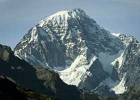
-
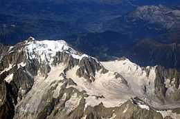
North side of Mont Blanc
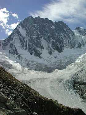
-
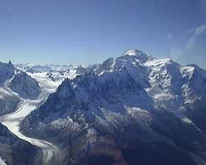
Mer de Glace glacier on the left
-
Mont Blanc seen from SPOT satellite
-
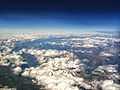
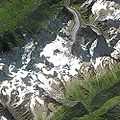
Aerial view of the south-western side of Mont Blanc in early September, taken on a commercial flight
See also
- Exploration of the High Alps
- Haute Route
- List of mountains
- Mons Blanc
- Mont Blanc glacier flood
- Mont Blanc massif
- Mont Blanc Tramway
- Mont Blanc Tunnel
- Tour du Mont Blanc
- Top of the Mont Blanc
References
- Rey, Guido, The Matterhorn (translated J. E. C. Eaton), London, 1907[33]
Footnotes
- ↑ The Caucasus watershed has conventionally been used as the boundary between Europe and Asia since the mid 19th century. The Caucasus has a number of peaks higher than Mont Blanc either marking the Russian-Georgian border or just within Russia (Mount Elbrus in the North Caucasus at 5641 m is the highest peak in Europe when including the Caucasus).
- ↑ 2.0 2.1 Mont Blanc shrinks by 45cm in two years
- ↑ the prominence of 4,696 m for Mont Blanc is taken from the "Ultras Project" (peaklist.org), "List compiled 2004 by Petter Bjørstad, Jonathan de Ferranti, Eberhard Jurgalski, Vasja Kavcic and Aaron Maizlish". A footnote to this entry at peaklist.org reads: "See the discussion on Wikipedia about recent measurements for Mont Blanc. A 2003 survey of Mont Blanc provided a new official (IGN) elevation of 4810m. Subsequent surveys have provided 4808.45 and most recently 4808.75 meter elevation. The summit has glacial cover to a depth of ±23 meters, thus annual fluctuation should be expected. (Citation). The Mont Blanc key saddle has been identified in Northern Russia near Ozero Onezhskoye." See also list of Alpine peaks by prominence.
- ↑ Green, Stewart. "Facts About Mont Blanc — Highest Mountain in Western Europe". About.com. Retrieved 7 August 2011.
- ↑ Muza, SR; Fulco, CS; Cymerman, A (2004). "Altitude Acclimatization Guide.". US Army Research Inst. of Environmental Medicine Thermal and Mountain Medicine Division Technical Report (USARIEM-TN-04-05). Retrieved 2009-03-05.
- ↑ Cymerman, A; Rock, PB. "Medical Problems in High Mountain Environments. A Handbook for Medical Officers". USARIEM-TN94-2. US Army Research Inst. of Environmental Medicine Thermal and Mountain Medicine Division Technical Report. Retrieved 2009-03-05.
- ↑ La disfida del Monte Bianco(in Italian).
- ↑ Historical map
- ↑ The map is based on measurements taken in 1856 before the convention of 7 March 1861, and is identical to the map attached to the Treaty of Turin. See IGN
- ↑ Assemblée Nationale: traité franco-italien signé à Turin le 26 mars 1860
- ↑ Image:1823 Mont Blanc 1.jpg
- ↑ Janssen et l'observatoire du sommet du mont Blanc (1893-1909), JM. Malherbe, Observatoire de Paris, section de Meudon
- ↑ The glacier des Bossons : plane crashes:
- ↑ BBC on this day 24 January 1966: 117 die in Air India tragedy
- ↑ Diplomatic bag contents revealed
- ↑ Timeline of the Mont Blanc Tunnel
- ↑ Mont Blanc Tunnel at age 46
- ↑ Vincent, Christian (2004-08-02). "The rock summit of the Mont Blanc, 40 m west of the ice summit". Centre National de la Recherche Scientifique. Retrieved 2015-04-29.
- ↑ Routes description, from camptocamp.org
- ↑ File:Le-Grand-Couloir.jpg – Wikimedia Commons
- ↑ , BBC
- ↑ http://www.flight-system.com/HGiraud01.htm
- ↑ Danish Artist Drapes Mont Blanc in Red, June 8, 2007
- ↑ Jaccuzzi (sic) on Mont-Blanc summit
- ↑ "Former Olympic champion Ruby dies in climbing fall". Archived from the original on 2009-06-11. Retrieved 2011-08-20.
- ↑ , ’50' pilots topland Mont Blanc as Chamonix sees record day, XC Mag, August 19, 2012
- ↑ "Tribute for 2 mountain climbers killed in France". Irish Sun.com. Retrieved 28 July 2014.
- ↑ "Climbers die near Mont Blanc in the French Alps". http://www.bbc.co.uk/news''. BBC News. Retrieved 14 August 2014.
- ↑ "Massif du Mont Blanc". UNESCO World Heritage Centre. Retrieved 2011-01-10.
- ↑ pro-mont-blanc.org
- ↑ "Europe's highest toilet". Ananova. Archived from the original on 2008-12-08. Retrieved 2011-08-20.
- ↑ "Warming threatens safety on Mont Blanc". The Times (UK). May 28, 2013.
- ↑ Rey's Il Monte Cervino was first published in Italian and appeared in English in 1907, in a translation by J. E. C. Eaton; a revised edition, with two further chapters by R. L. G. Irving, was published in Oxford by Basil Blackwell, 1946, and reprinted in 1949
External links
| Wikimedia Commons has media related to Mont Blanc. |
- Mont Blanc at 4000er.de (in German)
- Places to visit around Mont Blanc
- Mont-Blanc summit webcam: Close up of the summit of the Mont Blanc and its glaciers at 4811m.
- Mont-Blanc panoramic webcam: See severals points of view of the Mont-Blanc range and zoom on the top.
- Mont Blanc on Peakware
- Mont Blanc on Summitpost
- Descent into the Ice Companion web site to the PBS NOVA program which follows a glaciologist and a climber into the glacier caves of Mont Blanc
- Chamonix-Mont-Blanc Map
- The scientific observatories on Mont Blanc.
- Why Is Mont Blanc One of the World's Deadliest Mountains?
-
 Chisholm, Hugh, ed. (1911). "Blanc, Mont". Encyclopædia Britannica (11th ed.). Cambridge University Press.
| ||||||||||||||||||||||||||||||||||||||
| ||||||||||||||||||||||||||||||||||