Mont-ral
| Mont-ral | ||
|---|---|---|
| municipality | ||
|
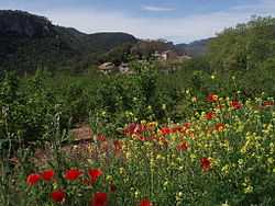
View of La Farena village | ||
| ||
 Mont-ral | ||
| Coordinates: 41°17′21″N 1°20′30″E / 41.28917°N 1.34167°E | ||
| Country | Spain | |
| Autonomous community | Catalonia | |
| Province | Tarragona | |
| Comarca | Alt Camp | |
| Government | ||
| • Mayor | Pere Venrell Mestrich | |
| Area | ||
| • Total | 34.69 km2 (13.39 sq mi) | |
| Elevation | 888 m (2,913 ft) | |
| Population (2010) | ||
| • Total | 172 | |
| • Density | 5.0/km2 (13/sq mi) | |
| Demonym | Mont-ralencs | |
| Time zone | CET (UTC+1) | |
| • Summer (DST) | CEST (UTC+2) | |
| Postal code | 43364 | |
Mont-ral (in Spanish, Montreal) is a municipality in the comarca of Alt Camp, Tarragona, Catalonia, Spain.
The Prades Mountains are located within this municipal term.
History
Mont-ral was part of the Montblanc Vegueria until 1716. Later it became part of the Tarragona Corregiment administrative division.[1]
This municipality had over 1,000 inhabitants during the second half of the 19th century, but has lost almost 80% of its population since then.[2]
Villages
- L'Aixàviga, 14
- El Bosquet, 24
- La Cabrera, 3
- La Cadeneta, 12
- Farena 46
- Mont-ral 81
References
- ↑ Josep M. Calbet & Teresa M. Jové, Alt Camp: marc físic marc humà. Generalitat de Catalunya, Valls, 1983 ISBN 84-300-8291-3
- ↑ INE - Municipal Register: Official Population Figures since 1996
External links
| Wikimedia Commons has media related to Mont-ral. |
- Official website
- Tourist information
- Informació de la Generalitat de Catalunya
- Informació de l'Institut d'Estadística de Catalunya
 |
Prades | Montblanc | La Riba | |
| Capafonts | |
Alcover | ||
| ||||
| | ||||
| Vilaplana | L'Albiol |
| ||||||||