Monroe County, Iowa
| Monroe County, Iowa | |
|---|---|
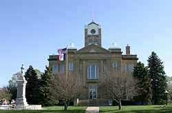 The courthouse in Albia is on the NRHP | |
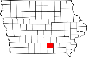 Location in the state of Iowa | |
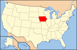 Iowa's location in the U.S. | |
| Founded | 1843 |
| Seat | Albia |
| Largest city | Albia |
| Area | |
| • Total | 434 sq mi (1,124 km2) |
| • Land | 434 sq mi (1,124 km2) |
| • Water | 0.6 sq mi (2 km2), 0.1% |
| Population | |
| • (2010) | 7,970 |
| • Density | 18/sq mi (7/km²) |
| Congressional district | 2nd |
| Time zone | Central: UTC-6/-5 |
| Website |
monroecoia |
Monroe County is a county located in the U.S. state of Iowa. As of the 2010 census, the population was 7,970.[1] The county seat is Albia.[2]
Geography
According to the U.S. Census Bureau, the county has a total area of 434 square miles (1,120 km2), of which 434 square miles (1,120 km2) is land and 0.6 square miles (1.6 km2) (0.1%) is water.[3]
Major highways
 U.S. Highway 34
 Iowa Highway 5
 Iowa Highway 137
Adjacent counties
- Marion County (northwest)
- Mahaska County (northeast)
- Wapello County (east)
- Appanoose County (south)
- Lucas County (west)
Demographics
| Historical population | |||
|---|---|---|---|
| Census | Pop. | %± | |
| 1850 | 2,884 | — | |
| 1860 | 8,612 | 198.6% | |
| 1870 | 12,724 | 47.7% | |
| 1880 | 13,719 | 7.8% | |
| 1890 | 13,666 | −0.4% | |
| 1900 | 17,985 | 31.6% | |
| 1910 | 25,429 | 41.4% | |
| 1920 | 23,467 | −7.7% | |
| 1930 | 15,010 | −36.0% | |
| 1940 | 14,553 | −3.0% | |
| 1950 | 11,814 | −18.8% | |
| 1960 | 10,463 | −11.4% | |
| 1970 | 9,357 | −10.6% | |
| 1980 | 9,209 | −1.6% | |
| 1990 | 8,114 | −11.9% | |
| 2000 | 8,016 | −1.2% | |
| 2010 | 7,970 | −0.6% | |
| Est. 2013 | 8,012 | 0.5% | |
2010 census
The 2010 census recorded a population of 7,970 in the county, with a population density of 18.389/sq mi (7.100/km2). There were 3,884 housing units, of which 3,213 were occupied.[8]
2000 census

As of the census[9] of 2000, there were 8,016 people, 3,228 households, and 2,211 families residing in the county. The population density was 18 people per square mile (7/km²). There were 3,588 housing units at an average density of 8 per square mile (3/km²). The racial makeup of the county was 98.40% White, 0.20% Black or African American, 0.36% Native American, 0.40% Asian, 0.12% from other races, and 0.51% from two or more races. 0.50% of the population were Hispanic or Latino of any race.
There were 3,228 households out of which 30.50% had children under the age of 18 living with them, 56.20% were married couples living together, 8.60% had a female householder with no husband present, and 31.50% were non-families. 28.00% of all households were made up of individuals and 15.30% had someone living alone who was 65 years of age or older. The average household size was 2.43 and the average family size was 2.97.
In the county the population is spread out with 25.30% under the age of 18, 7.20% from 18 to 24, 25.00% from 25 to 44, 23.00% from 45 to 64, and 19.50% who were 65 years of age or older. The median age was 40 years. For every 100 females there were 94.90 males. For every 100 females age 18 and over, there were 92.60 males.
The median income for a household in the county was $34,877, and the median income for a family was $41,611. Males had a median income of $31,667 versus $21,401 for females. The per capita income for the county was $17,155. About 5.60% of families and 9.00% of the population were below the poverty line, including 12.20% of those under age 18 and 5.90% of those age 65 or over.
Communities
Cities
Unincorporated community
Ghost town
- Buxton
See also
References
- ↑ 1.0 1.1 "State & County QuickFacts". United States Census Bureau. Retrieved July 20, 2014.
- ↑ "Find a County". National Association of Counties. Retrieved 2011-06-07.
- ↑ "US Gazetteer files: 2010, 2000, and 1990". United States Census Bureau. 2011-02-12. Retrieved 2011-04-23.
- ↑ "U.S. Decennial Census". United States Census Bureau. Retrieved July 20, 2014.
- ↑ "Historical Census Browser". University of Virginia Library. Retrieved July 20, 2014.
- ↑ "Population of Counties by Decennial Census: 1900 to 1990". United States Census Bureau. Retrieved July 20, 2014.
- ↑ "Census 2000 PHC-T-4. Ranking Tables for Counties: 1990 and 2000" (PDF). United States Census Bureau. Retrieved July 20, 2014.
- ↑ "Population & Housing Occupancy Status 2010". United States Census Bureau American FactFinder. Retrieved May 31, 2011.
- ↑ "American FactFinder". United States Census Bureau. Retrieved 2008-01-31.
External links
| Wikimedia Commons has media related to Monroe County, Iowa. |
 |
Marion County | Mahaska County | | |
| Lucas County | |
Wapello County | ||
| ||||
| | ||||
| Appanoose County |
| |||||||||||||||||||||||||
Coordinates: 41°01′42″N 92°52′12″W / 41.02833°N 92.87000°W