Monreal, Germany
| Monreal | ||
|---|---|---|
| ||
 Monreal | ||
Location of Monreal within Mayen-Koblenz district 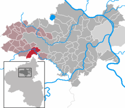 | ||
| Coordinates: 50°18′0″N 7°9′34″E / 50.30000°N 7.15944°ECoordinates: 50°18′0″N 7°9′34″E / 50.30000°N 7.15944°E | ||
| Country | Germany | |
| State | Rhineland-Palatinate | |
| District | Mayen-Koblenz | |
| Municipal assoc. | Vordereifel | |
| Government | ||
| • Mayor | Karl Schmitz | |
| Area | ||
| • Total | 14.64 km2 (5.65 sq mi) | |
| Population (2012-12-31)[1] | ||
| • Total | 817 | |
| • Density | 56/km2 (140/sq mi) | |
| Time zone | CET/CEST (UTC+1/+2) | |
| Postal codes | 56729 | |
| Dialling codes | 02651 | |
| Vehicle registration | MYK | |
| Website | www.monreal-eifel.de | |

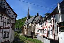
The Parish in Monreal, along the Eltzbach
Monreal is a municipality in the district of Mayen-Koblenz in Rhineland-Palatinate, Germany.
References
- ↑ "Bevölkerung der Gemeinden am 31.12.2012". Statistisches Bundesamt (in German). 2013.