Mongkung State
| Mongkung (Möngküng) | |||||
| State of the Shan States | |||||
| |||||
 | |||||
| History | |||||
| - | State founded | 1835 | |||
| - | Abdication of the last Saopha | 1959 | |||
| Area | |||||
| - | 1901 | 2,650 km2 (1,023 sq mi) | |||
| Population | |||||
| - | 1901 | 30,482 | |||
| Density | 11.5 /km2 (29.8 /sq mi) | ||||
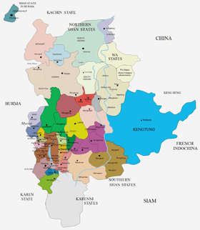
Mongkung or Möngküng (Burmese: Maingkaing) was a Shan state in what is today Burma. It belonged to the Eastern Division of the Southern Shan States. Its capital was Mong Kung, in the valley of the Nam Teng. The largest minority were Palaung people.
History
Mongkung state was founded in ancient times as Langkavadi. In 1835, after the British annexed Upper Burma and established their rule in the region, Mongkung had been formerly a feudatory state of Hsenwi.[1]
Rulers
The rulers of Mongkung bore the title Myoza in 1835-54 and 1863-73; Saopha in 1854-63 and from 1873.[2]
Saophas and Myozas
- 1835 - 1860 Hkun Long (d. 1860)
- 1860 - 1863 Hkun Long II
- 1863 - 1873 Gu Na (d. 1873)
- 1873 - 1879 Hkun San Kwan
- 1879 - .... Hkun Mong (b. 1873 - d. ....)
- 1879 - 1883 Heng Hkon Sang -Regent
References
External links
- "Gazetteer of Upper Burma and the Shan states"
- The Imperial Gazetteer of India
- "WHKMLA : History of the Shan States". 18 May 2010. Retrieved 21 December 2010.
| ||||||||||||||||||||||||||||||
Coordinates: 21°36′N 97°31′E / 21.600°N 97.517°E