Mong Hsu Township
| Mong Hsu | |
|---|---|
| Township | |
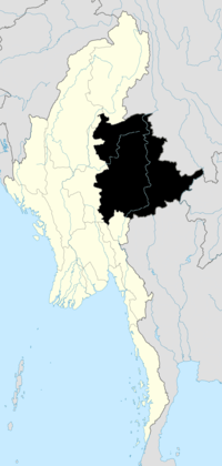
 Mong Hsu Location in Burma | |
| Coordinates: 21°54′20″N 98°21′10″E / 21.90556°N 98.35278°ECoordinates: 21°54′20″N 98°21′10″E / 21.90556°N 98.35278°E | |
| Country |
|
| State | Shan State |
| District | Loilem District |
| Elevation[1] | 707 m (2,320 ft) |
| Time zone | MST (UTC+6.30) |
Mong Hsu Township is a township of Loilen District in the Shan State of Myanmar. The principal town is Mong Hsu. Om-pu waterfall on Nam Parng River of Mong Hsu is the second largest waterfall of Shan State.[2] The nearest commercial airport to Mong Hsu is Lashio Airport.
History
Mong Hsu is the home of the famous Mong Hsu ruby mines.[3] The large scale production started in 1991.[4] Before gems were found, it is a small remote town with 1-2 convoys for each month. And before 1959, it was governed by a sawbwa.[5] Starting from 1992, rubies from Mong Hsu dominate the world ruby market of less than 3 ct. Or 99% of all rubies traded in Chanthaburi are from Mong Hsu.[6] The quality of its rubies is inferior to that of Mogok.
There was forced displacement of native Shan population in Mong Hsu Township by the Myanmar Army in 1995.[7] And several skirmishes between Myanmar Army and Shan State Army in 2011.[8]
References
| ||||||||||