Moncreiffe Hill
| Moncreiffe Hill | |
|---|---|
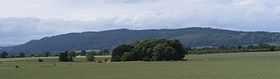 Moncreiffe Hill from the south east | |
| Elevation | 223 m (732 ft) |
| Prominence | 186 m (610 ft) |
| Listing | Marilyn |
| Location | |
| Location | Perth, Scotland |
| Range | none, stands alone |
| OS grid | NO135199 |
| Topo map | OS Landranger 58 |

Moncreiffe Hill is a long, wooded ridge that lies south of Perth, Scotland. It can be easily seen on the right during the final stages of the drive north towards Perth on the M90 motorway. Unlike most British hills, the routes to the summit are almost entirely under tree cover, although the summit area, which is known as Moredun Top, is clear and offers impressive views over Perth and the Firth of Tay.
The shortest route to the summit is from the north, starting at NO132209, but car parking at the location, while not impossible, is evidently not encouraged. A more commonly used route to the summit, albeit a longer route, starts from the south east, starting at NO153192, which is signposted from the nearest public road and where there is sufficient parking space.
A wide variety of trees and other vegetation grow on the hill, which is managed by Scottish Woodlands. There are information boards and several marked trails.
Anyone seeking peace and solitude on this hill can expect to be accompanied by the continuous drone of traffic from the M90 motorway.