Moncontour, Vienne
| Moncontour | ||
|---|---|---|
|
The village of Moncontour | ||
| ||
 Moncontour | ||
|
Location within Poitou-Charentes region 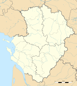 Moncontour | ||
| Coordinates: 46°52′57″N 0°00′57″W / 46.8825°N 0.0158°WCoordinates: 46°52′57″N 0°00′57″W / 46.8825°N 0.0158°W | ||
| Country | France | |
| Region | Poitou-Charentes | |
| Department | Vienne | |
| Arrondissement | Châtellerault | |
| Canton | Moncontour | |
| Government | ||
| • Mayor (2001–2008) | Édouard Renaud | |
| Area1 | 41.06 km2 (15.85 sq mi) | |
| Population (2006)2 | 1,030 | |
| • Density | 25/km2 (65/sq mi) | |
| INSEE/Postal code | 86161 / 86330 | |
| Elevation |
51–115 m (167–377 ft) (avg. 70 m or 230 ft) | |
|
1 French Land Register data, which excludes lakes, ponds, glaciers > 1 km² (0.386 sq mi or 247 acres) and river estuaries. 2 Population without double counting: residents of multiple communes (e.g., students and military personnel) only counted once. | ||

.svg.png)
Moncontour is a commune in the Vienne department in the Poitou-Charentes region in western France.
It was the site of the Battle of Moncontour in 1569.
Demographics
| Year | 1962 | 1968 | 1975 | 1982 | 1990 | 1999 | 2006 |
|---|---|---|---|---|---|---|---|
| Population | 1019 | 1171 | 1061 | 1036 | 929 | 980 | 1030 |
Sites and monuments
-
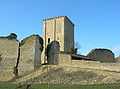
Moncontour dungeon
-

Lake of Moncontour
-

Recreation spot, built in 2006
See also
References
External links
| Wikimedia Commons has media related to Moncontour (Vienne). |
- (French) Mayor's Office
- (French) Communauté de Communes du Pays Loudunais - CCPL
- (French) Moncontour on Quid
- (French) Moncontour on a map of France
- (English) Moncontour on Mapquest
- (French) Aerial view of Moncontour.
- (French) EXO Active Park
- (French) http://www.moncontour-active-park.fr