Moldøen
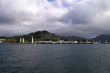 View of the industrial part of the island | |
| Geography | |
|---|---|
| Location | Sogn og Fjordane, Norway |
| Coordinates | 61°55′43″N 5°07′06″E / 61.92865°N 5.118425°ECoordinates: 61°55′43″N 5°07′06″E / 61.92865°N 5.118425°E |
| Area | 7.24 ha (17.9 acres) |
| Length | 400 m (1,300 ft) |
| Width | 260 m (850 ft) |
| Coastline | 1.2 km (0.75 mi) |
| Country | |
| County | Sogn og Fjordane |
| Municipality | Vågsøy Municipality |
Moldøen (also known as Lisjemåløyna, Øyna, or Måløy Island) is a small island in Vågsøy Municipality in Sogn og Fjordane county, Norway. It is located immediately east of the town of Måløy in the Ulvesund strait between the large island of Vågsøy and the village of Degnepoll on the mainland. This island was the original site of the town of Måløy. The town has since spread onto the island of Vågsøy, where the majority of the town is now located.
During World War II, Moldøen was the site of a German coastal fort. Operation Archery took place on and around the island. Today, the island is connected to Måløy by a land-filled causeway and is the site of a park featuring the remains of the German fort, two memorials of World War II and a disc golf course. The island also has a modern rope and trawl factory, a large freeze warehouse, and an ISPS port. The island is also the base for several pillars that support the Måløy Bridge which connects the island of Vågsøy to the mainland.[1]
References
- ↑ Store norske leksikon. "Måløy" (in Norwegian). Retrieved 2010-07-22.