Mojanda
| Mojanda | |
|---|---|
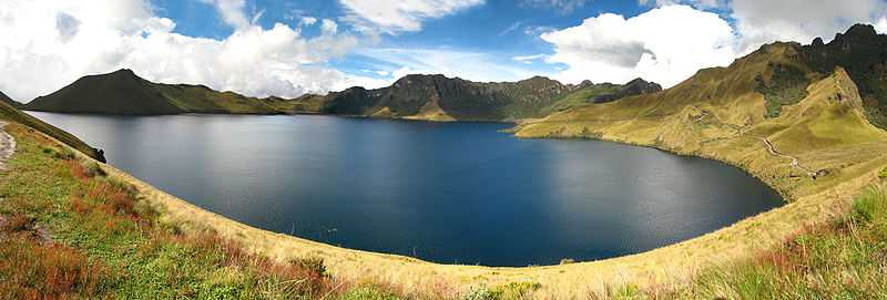
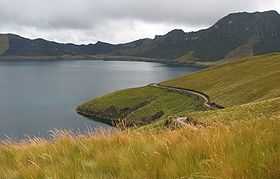 Caricocha in the Mojanda caldera. On the opposite side of lake, the páramo has been burned away to promote new growth for cattle grazing. | |
| Elevation | 4,263 m (13,986 ft) |
| Location | |
| Location | Between Imbabura and Pichincha provinces, Ecuador |
| Range | Andes |
| Coordinates | 0°08′N 78°16′W / 0.13°N 78.27°WCoordinates: 0°08′N 78°16′W / 0.13°N 78.27°W |
| Geology | |
| Type | Inactive stratovolcano |
| Last eruption | Middle Pleistocene |
Mojanda is an inactive stratovolcano of the Eastern Cordillera of the Andes in northern Ecuador. A summit caldera, which was produced by an explosive Plinian Eruption that marked the end of Mojanda activity 200,000 years ago, is occupied by three crater lakes: Karikucha (the largest), Yanakucha, and Warmikucha.[1] Having received protected status in 2002, they are a popular tourist destination and are about 20 minutes taxi ride from the largely indigenous town of Otavalo.
Mojanda is a complex of two volcanoes which were active simultaneously. The volcanic vents are only 3 km apart. The other volcano, which produced at least two Plinian Eruptions of its own, is known as Fuya Fuya. Fuya Fuya partially collapsed around 165,000 years ago, creating a large caldera to the west. A new volcanic cone and other lava domes subsequently extruded inside the caldera, probably during the Late Pleistocene.[2]
The high altitude grasslands and shrublands of Mojanda, which lie above the cloud forests, are collectively known as páramo. They are frequently grazed by cattle.
See also
References
- ↑ "Potential hazards in case of unrest at Mojanda - Fuya Fuya volcanic complex, Ecuador" (DOC). Retrieved 2006-03-17.
- ↑ "Mojanda". Global Volcanism Program. Smithsonian Institution. Retrieved 2006-03-17.