Mogán, Las Palmas
| Mogán | |||
|---|---|---|---|
| Municipality | |||
|
Mogán port | |||
| |||
 Municipal location in Gran Canaria | |||
 Mogán Location in the Canary Islands | |||
| Coordinates: 27°53′1″N 15°43′24″W / 27.88361°N 15.72333°WCoordinates: 27°53′1″N 15°43′24″W / 27.88361°N 15.72333°W | |||
| Country | Spain | ||
| Autonomous Region | Canary Islands | ||
| Province | Las Palmas | ||
| Island | Gran Canaria | ||
| Government | |||
| • Mayor | Francisco González (PP) | ||
| Area[1] | |||
| • Total | 172.44 km2 (66.58 sq mi) | ||
| Elevation(AMSL) | 253 m (830 ft) | ||
| Population (2013)[2] | |||
| • Total | 21,782 | ||
| • Density | 130/km2 (330/sq mi) | ||
| Time zone | CET (UTC+0) | ||
| • Summer (DST) | CEST (GMT +1) (UTC+1) | ||
| Postal code | 35140 | ||
| Area code(s) | +34 (Spain) + 928 (Las Palmas) | ||
| Website | www.mogan.es | ||
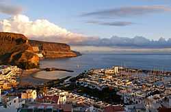
Mogán is a town and a municipality in the southwestern part of the island of Gran Canaria, which is one of the three main islands making up the Province of Las Palmas in the Canary Islands, Spain. Its population is 21,782 (2013),[2] and the area is 172.44 km².[1]
Geography
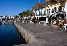
Mogán is the second largest municipality by area on the island. It includes the fishing towns of Puerto de Mogán and Arguineguín. Much of the population lives on the Atlantic coastline. The town of Mogán is about 8 kilometres from the coast, 11 km north of Puerto Rico de Gran Canaria and 40 km southwest of Las Palmas. The GC-1 motorway passes through the south of the municipality. There is a string of tourist resorts along the coast.
The main settlements are:
- Arguineguín
- Cornisa del Suroeste
- Mogán
- Playa de Mogán
- Puerto de Mogán
- Puerto Rico
Historical population

| Year | Population |
|---|---|
| 1991 | 8,688 |
| 1996 | 10,398 |
| 2001 | 12,444 |
| 2002 | 15,935 |
| 2003 | 15,932 |
| 2004 | 15,176 |
| 2013 | 21,782 |
See also
References
- ↑ 1.0 1.1 Instituto Canario de Estadística, area
- ↑ 2.0 2.1 Instituto Canario de Estadística, population
External links
 |
La Aldea de San Nicolás | Tejeda | | |
| |
San Bartolomé de Tirajana | |||
| ||||
| | ||||
| Atlantic Ocean |
| ||||||||||||||||