Moculta, South Australia
| Moculta South Australia | |||||||||||||
|---|---|---|---|---|---|---|---|---|---|---|---|---|---|
|
Gnadenberg Church and the Hill of Grace wineyard | |||||||||||||
 Moculta | |||||||||||||
| Coordinates | 34°28′12″S 139°07′01″E / 34.4699°S 139.1169°ECoordinates: 34°28′12″S 139°07′01″E / 34.4699°S 139.1169°E | ||||||||||||
| Established | 1842 | ||||||||||||
| Postcode(s) | 5353 | ||||||||||||
| Location | 12 km (7 mi) NE of Angaston | ||||||||||||
| LGA(s) | Barossa Council | ||||||||||||
| State electorate(s) | Schubert | ||||||||||||
| Federal Division(s) | Barker | ||||||||||||
| |||||||||||||

Moculta is a settlement in South Australia.[1] At the 2006 census, Moculta had a population of 299.[2]
The earliest settlers in the area were English, Scottish and Irish migrants. German migrants also came to the area from 1853. They built both the Gruenberg (1859) and Gnadenberg Lutheran churches. The township of Moculta itself was surveyed in 1865 and occupied soon after.[3]
Gallery
-
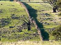
A dry stone wall at Mt Karinya near Moculta, South Australia.
-

A dry stone wall at Mt Karinya near Moculta, South Australia.
-

The restored cottage of the Rosenzweig's at Moculta, built circa 1859 with farm equipment in the foreground.
-

The ruins of the Shannon family's farmhouse at Moculta. Since this photo was taken the ruins have collapsed. The steeple of the Gruenberg Lutheran church can be seen in the background].
-

The Shannon family mausoleum outside of Moculta, South Australia.
-

The Swan Reach to Stockwell Pipeline at Moculta, South Australia.
References
| Wikimedia Commons has media related to Moculta, South Australia. |
- ↑ "2905.0 - Statistical Geography: Volume 2 -- Census Geographic Areas, Australia, 2006". Australian Bureau of Statistics. Retrieved 8 December 2009.
- ↑ Australian Bureau of Statistics (25 October 2007). "Moculta (State Suburb)". 2006 Census QuickStats. Retrieved 6 October 2011.
- ↑ "Moculta". Flinders Ranges Research. Retrieved 9 February 2015.
| ||||||||||