Mitchell's Pass
| Michell's Pass | |
|---|---|
|
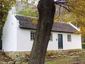
Former toll house on Michell's Pass | |
| Elevation | 490 m (1,608 ft) |
| Traversed by |
R46 road Ceres branch line railway (closed) |
| Location | Western Cape, South Africa |
| Range | Skurweberg Mountains |
| Coordinates | 33°22′44″S 19°17′47″E / 33.3788°S 19.2965°ECoordinates: 33°22′44″S 19°17′47″E / 33.3788°S 19.2965°E |
 | |
Michell's Pass is a mountain pass in the Western Cape province of South Africa which approaches the town of Ceres from the south-west, connecting it to Tulbagh, Worcester and the Breede River Valley. The pass is traversed by the R46 road and the (now closed) Ceres branch line railway. From its western entrance near Wolseley the pass ascends 190 metres (620 ft) to the summit at an elevation of 490 metres (1,610 ft), before descending a short distance into Ceres.
The pass was planned by Charles Collier Michell, Surveyor-General of the Cape Colony, for whom it was named.[1][2] It was constructed in 1848 by Andrew Geddes Bain. A railway line through the pass was constructed from 1910 to 1912. In 1938 the road was widened and concreted.
References
| Wikimedia Commons has media related to Mitchell's Pass. |
- ↑ "Mitchells Pass, Ceres". mountainpassessouthafrica. Retrieved 18 November 2012.
- ↑ Raper, R.E. Dictionary of Southern African Place Names. Human Sciences Research Council (South Africa).