Misool
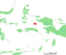 Location of Misool | |
 | |
| Geography | |
|---|---|
| Location | South East Asia |
| Archipelago | Raja Ampat Islands |
| Highest elevation | 535 m (1,755 ft) |
| Country | |
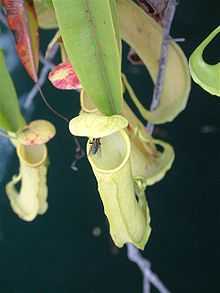
Aerial traps of the pitcher plant Nepenthes sp. Misool.
Misool, formerly spelled Mysol, (Dutch: Misoöl), is one of the four major islands in the Raja Ampat Islands in West Papua (formerly Irian Jaya), Indonesia. Its area is 2,034 km². The highest point is 535 m and the main towns are Waigama, located on the island's northern coast, and Lilinta.
The inhabitants speak the Biga language and Matbat language, as well as Indonesian.[1][2]
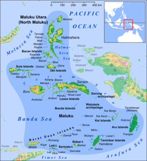
Other main islands of this group off the western end of West Papua are Salawati, Batanta and Waigeo, and there are numerous smaller islands such as Kofiau.[3]
Fauna
- Echymipera kalubu, Common Spiny Bandicoot
- Echymipera rufescens
- Dorcopsis muelleri
- Phalanger orientalis
- Spilocuscus maculatus
- Petaurus breviceps
- Macroglossus minimus
- Melanotaenia flavipinnis and Melanotaenia misoolensis, Misool rainbowfish[4][5]
- Nyctimene aello
- Pteropus conspicillatus
- Aselliscus tricuspidatus
- Pipistrellus papuanus
History
Part of the Dutch colonial empire, the Netherlands East Indies.
Occupied on 1942 by the Japanese. Imperial Japanese Navy base until 1945.[6]
References
- ↑ Ethnologue - Biga
- ↑ Ethnologue - Matbat
- ↑ Traditional kingdoms of Maluku, early 15th century, and the spheres of influence of Ternate and Tidore, early 16th century
- ↑ Allen, G.R., Hadiaty, R.K. & Unmack, P.J. (2014): Melanotaenia flavipinnis, a new species of Rainbowfish (Melanotaeniidae) from Misool Island, West Papua Province, Indonesia, aqua, International Journal of Ichthyology, 20 (1): 35-52.
- ↑ Allen, G. 1996. Melanotaenia misoolensis. 2006 IUCN Red List of Threatened Species. Downloaded on 4 August 2007.
- ↑ No. 92 of the Japanese Monographs — "Southwest Area Naval Operations, Apr. 1942 – Apr. 1944", 10 September 1947.
External links
 Media related to Misool at Wikimedia Commons
- Jelle Miedema, Perspectives on the Bird's Head of Irian Jaya, Indonesia: Proceedings of the Conference Leiden, 13-17 October 1997
- Indonesia Field Project - Misool - Marine Conservation Agreements
Coordinates: 1°53′41″S 130°5′1″E / 1.89472°S 130.08361°E