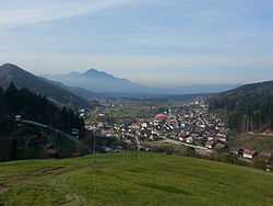
Mislinja (settlement)
| Mislinja | |
|---|---|
 | |
_location_map.svg.png) Mislinja Location of the settlement of Mislinja in Slovenia | |
| Coordinates: 46°26′35″N 15°11′35″E / 46.44306°N 15.19306°ECoordinates: 46°26′35″N 15°11′35″E / 46.44306°N 15.19306°E | |
| Country |
|
| Traditional region | Styria |
| Statistical region | Carinthia |
| Municipality | Mislinja |
| Government | |
| • Mayor | Viktor Robnik |
| Area | |
| • Total | 112.2 km2 (43.3 sq mi) |
| Population (2011)[1] | |
| • Total | 1,945 |
| • Density | 17/km2 (45/sq mi) |
| Time zone | CET (UTC+01) |
| • Summer (DST) | CEST (UTC+02) |
Mislinja (pronounced [miˈsliːnja]) is a settlement in northern Slovenia. It is the seat of the Municipality of Mislinja. It lies in the valley of the Mislinja River. Although the area has traditionally belonged to Styria, since 1995, it is included in the Carinthia Statistical Region.[2]
Name
Mislinja was first attested in written sources in 1335 and 1404 as Misling (and as Missling in 1460). The name is derived from an earlier hydronym, *Myslin'a (voda) (literally, 'Myslinъ's creek'), thus referring to people living along the creek. The hypocorism *Myslinъ is derived from the personal name *Myslь.[3]
Churches

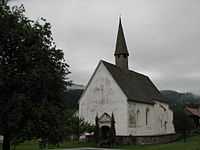
There are two churches in the settlement, both belonging to the Parish of Šentilj pod Turjakom. One is dedicated to Saint Leonard and was built in the mid-17th century on the site of an earlier church, first mentioned in written documents dating to 1476. The second is dedicated to Saint Agathius. It was built in the Gothic style in the 14th century and is preserved more or less in its original from.[4]
Mass graves
Mislinja is the site of six known mass graves from the period immediately after the Second World War. All of them contain the remains of victims murdered between 10 and 15 May 1945. The Railroad 1, 2, and 3 mass graves (Slovene: Grobišče ob železniški progi 1, 2, 3) are located west of the settlement, south of the former railroad from Mislinja to Slovenj Gradec. They contain an unknown number of victims.[5][6][7] The Railroad 4 Mass Grave (Grobišče ob železniški progi 4) is located west of the settlement in a meadow north of the former railroad. It contains an unknown number of victims.[8] The Movže 1 and 2 mass graves (Grobišče Movže 1, 2) are located south of the settlement. Both are former anti-tank trenches and contain the remains of a large number of Ustaša soldiers and Croatian civilians. The Movže 1 Mass Grave is south of the Abršek farm at Movže no. 24.[9] The Movže 2 Mass Grave is located between the road and the railroad.[10]
References
- ↑ Place Names, SORS
- ↑ Mislinja municipal site
- ↑ Snoj, Marko. 2009. Etimološki slovar slovenskih zemljepisnih imen. Ljubljana: Modrijan and Založba ZRC, p. 264.
- ↑ Slovenian Ministry of Culture register of national heritage reference numbers ešd 3016 & 3017
- ↑ Railroad 1 Mass Grave on Geopedia (Slovene)
- ↑ Railroad 2 Mass Grave on Geopedia (Slovene)
- ↑ Railroad 3 Mass Grave on Geopedia (Slovene)
- ↑ Railroad 4 Mass Grave on Geopedia (Slovene)
- ↑ Movže 1 Mass Grave on Geopedia (Slovene)
- ↑ Movže 2 Mass Grave on Geopedia (Slovene)
External links
| Wikimedia Commons has media related to Mislinja. |
- Mislinja on Geopedia (map, aerial photograph)
- Mislinja on Google Maps (map, photographs, street view)
| ||||||||||||||||||
