Misima Island

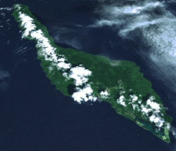

Misima (formerly called St. Aignan) is a volcanic island in the northwest of Louisiade Archipelago within Milne Bay Province of Papua New Guinea. The island measures 40 km by 10 km and has an area of 202,5 km². It is located some 20 km north of the northwest extreme of the barrier reef of Vanatinai at Isu Raua Raua Island, and 80 km northwest of Vanatinai Island itself. Misima is mountainous and densely forested. Mt. Koia Tau, at a height of 1,036 meters, is the highest peak of the Louisiade Archipelago. The island is within the Samarai Murua District.
The main town of the island and the seat of the district is Bwagaoia, located on the southeast corner of the island. Other villages are Hinauta, Boiou, Gulewa, Bagilina, Liak, Siagara, Eiaus (on the eastern north coast, reachable by road from Bwagaoia), Gulewa and Ewena or Ewana (on the western north coast), and Bwagabwaga, Gaibobo and Alhoga (on the south coast).[1] Misima has a working airport (four flights weekly to the mainland (POM via Alotau) through Airlines of Papua New Guinea, and one charter run by Porgera Joint Venture, a high school (grades 7-10), a small market, a few small stores and a clinic/hospital, a post office,--all of which are located in Bwagaoia. There are ferries from Alotau which service Misima Island, costing around K100 and taking 17 hours.
With a population of 5,000, Misima is the most heavily populated island in the archipelago. By area, it is the third largest, after Vanatinai and Rossel Island. A gold and silver mine was opened on the island in 1990 and officially closed in 2004.[2] The mine was a joint venture by Placer Dome Inc (owning 80%) and the state-owned Orogen Minerals Ltd. In March 2012 Barrick closed its post closure monitoring office in Bwagaoia having successfully rehabilitated the mine and mill sites.
Since 2004 when the mine closed, artisanal mining has become a major source of income in the island, with an association Misima Alluvial Gold Mining Association (MAGMA) starting in 2007. Other sources of income, especially for people living on the north coast, are cash crops of coconuts, copra, and cacao. A commercial fisheries project has been proposed, but has not been developed yet.
The main language of the island is also called Misiman, though many residents speak English and also Tok Pisin as a third language.
Transportation
The island is served by the Misima Island Airport (IATA: MIS, ICAO: AYMM).