Minnaert function
The Minnaert function is a photometric function used to interpret astronomical observations [1][2] and remote sensing data for the Earth.[3] This function expresses the radiance factor (RADF) as a function the phase angle ( ) and the photometric latitude (
 ) and the photometric longitude (
 ).
).
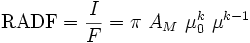
where  is the Minnaert albedo,
  is an empirical parameter,
  is the scattered radiance in the direction
  ,
,  is the incident radiance, and

The phase angle is the angle between the light source and the observer with the object as the center.
The assumptions made are:
- the surface is illuminated by a distant point source.
- the surface is isotropic and flat.
Minnaert's contribution is the introduction of the parameter , having a value between 0 and 1,[4] originally for a better interpretation of observations of the Moon. In remote sensing the use of this function is referred to as Minnaert topographic correction, a necessity when interpreting images of rough terrain.