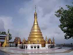
Minbya
| Minbya မင္းျပား | |
|---|---|
|
| |
 Minbya Location in Burma | |
| Coordinates: 20°09′00″N 92°54′00″E / 20.15000°N 92.90000°E | |
| Country |
|
| Division | Rakhine State |
| District | Sittwe District |
| Township | Minbya Township |
| Population (2006) | |
| • Total | 181,000 |
| • Ethnicities | Rakhine |
| • Religions | Buddhism |
| Time zone | MST (UTC+6.30) |
| Area code(s) | 42, 43 |
| [1] | |
Minbya (Burmese: မင်းပြားမြို့, pronounced: [mɪ́ɴbjá mjo̰]) is a town in the Rakhine State of westernmost part of Myanmar.
Education
BEHS Minbya is the one of the high schools in the town. Another two post- Middle schools.
Natural disasters
On 15 June 2010, strong rains destroyed more than 25 buildings, including houses, school buildings, and a mosque. Close to 200 people were housed in mosques of several nearby villages.[2]
On 12 November 2011, all 567 permanent shops of the Minbya central market were destroyed in a fire accident.[3]
External links
References
- ↑ "National Telephone Area Codes". Myanmar Yellow Pages.
- ↑ Myanmar: Downpours, strong winds cause death, injury, damage to houses, roads, railroad sections, floods, landslides State, departments, Tatmadawmen, NGOs and wellwishers render assistance for relief and rehabilitation
- ↑ http://www.mrtv3.net.mm/newpaper/1511newsn.pdf Page 6 Col 1
| |||||||||||||||||||||||||||||
Coordinates: 20°22′N 93°16′E / 20.367°N 93.267°E


