Milwaukee River

The Milwaukee River is a river in the state of Wisconsin. It is about 104 miles (167 km) long.[1]
Description
The river begins in Fond du Lac County, Wisconsin and flows south past Grafton to downtown Milwaukee, where it empties into Lake Michigan. Cedar Creek, the Menomonee River and the Kinnickinnic River are the three main tributaries.
Watershed

The Milwaukee River watershed drains 882 square miles (2,280 km2) in southeastern Wisconsin, including parts of Dodge, Fond du Lac, Milwaukee, Ozaukee, Sheboygan, Washington and Waukesha counties.
The Milwaukee River watershed is part of the Lake Michigan subbasin; this subbasin is itself a part of the St. Lawrence River Watershed, which is fed by the Great Lakes.
History
The Milwaukee River area was populated by Native Americans in the time before European settlement. Jacques Marquette and Louis Jolliet navigated from Lake Michigan through the Milwaukee River on their way to the Fox River and the Mississippi.
In the early 19th century, three towns were formed across the banks of the Milwaukee and Kinnickinnic rivers: Juneautown by Solomon Juneau, Walker's Point by George H. Walker and Kilbourntown by Byron Kilbourn. The quarrel over the formation of a bridge across the Milwaukee River was a key point in the merging of the three towns into the city of Milwaukee in 1846..
Bridges

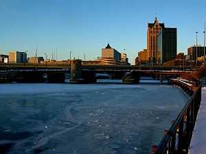
The Milwaukee River has numerous movable bridges spanning it, allowing for pedestrian and vehicular traffic. These bridges include several different types, including bascule and vertical lift bridges. There are also many fixed bridges, as well as several pedestrian-only and railroad trestles.
The following is a partial list of bridges that cross the river, from north to south:
- Brown Deer Road Bridge
- Range Line Road Bridge
- Good Hope Road Bridge
- Green Tree Road Bridge
- Bender Road Bridge
- Silver Spring Drive Bridge
- Hampton Avenue Bridge
- I-43 Bridge
- Port Washington Road Bridge
- Capitol Drive Bridge
- Locust Street Bridge
- North Avenue Bridge
- North-Humboldt Pedestrian Bridge
- Humboldt Street Bridge
- Holton Street Viaduct (1926)
- Pleasant Street Bridge
- Cherry Street Bridge
- McKinley Avenue Bridge aka Knapp Street Bridge
- Juneau Avenue Bridge
- Highland Avenue Pedestrian Bridge
- State Street Bridge
- Kilbourn Avenue Bridge
- Wells Street Bridge
- Wisconsin Avenue Bridge
- Michigan Street Bridge
- Clybourn Street Bridge
- I-794 Bridge
- Saint Paul Avenue Bridge
- Water Street Bridge
- Broadway Bridge aka Milwaukee Street Bridge
- Hoan Bridge
There are also several Union Pacific (former Chicago and North Western Railway) railroad bridges crossing the Milwaukee River, including:
Parks

There are several parks on the banks of the Milwaukee River. These include Estabrook, Gordon, Kern, Lincoln, Pere Marquette, Pleasant Valley, and Riverside Parks in Milwaukee, Kletsch Park in Glendale and Hubbard Park in Shorewood.
Dams
There are also several dams along the river.
See also
- List of Wisconsin rivers
- Milwaukee Riverwalk
References
- ↑ U.S. Geological Survey. National Hydrography Dataset high-resolution flowline data. The National Map, accessed May 19, 2011
External links
| Wikimedia Commons has media related to Milwaukee River. |
- Milwaukee River Advocates
- Milwaukee River Basin - Wisconsin DNR
- Milwaukee Green Map: Watersheds
- Milwaukee River Preservation Association
- Milwaukee Riverkeeper
- River Revitalization Foundation
- Milwaukee River Basin Partnership
- Milwaukee Estuary Area of Concern
- History of Port of Milwaukee
- Milwaukee River Greenway Coalition