Milower Land
Milower Land is a municipality in the Havelland district, in Brandenburg, Germany.
Demography
-
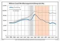
Development of Population since 1875 within the Current Boundaries (Blue Line: Population; Dotted Line: Comparison to Population Development of Brandenburg state; Grey Background: Time of Nazi rule; Red Background: Time of Communist rule)
-
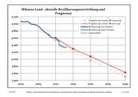
Recent Population Development (Blue Line) and Forecasts
Milower Land:
Population development within the current boundaries[2]
| Year |
Popul. |
|
|
|---|
| 1875 | 5042 |
| 1890 | 5089 |
| 1925 | 6550 |
| 1933 | 6205 |
| 1939 | 6464 |
| 1946 | 8095 |
| 1950 | 8448 |
| 1964 | 6501 |
| 1971 | 6279 |
| 1981 | 5343 |
|
|
| Year |
Popul. |
|
|
|---|
| 1985 | 5312 |
| 1989 | 5219 |
| 1990 | 5056 |
| 1991 | 4907 |
| 1992 | 4827 |
| 1993 | 4813 |
| 1994 | 4802 |
| 1995 | 4854 |
| 1996 | 4937 |
| 1997 | 5060 |
|
|
| Year |
Popul. |
|
|
|---|
| 1998 | 5074 |
| 1999 | 5083 |
| 2000 | 5068 |
| 2001 | 5052 |
| 2002 | 5061 |
| 2003 | 4994 |
| 2004 | 4977 |
| 2005 | 4938 |
| 2006 | 4839 |
| 2007 | 4756 |
|
|
| Year |
Popul. |
|
|
|---|
| 2008 | 4687 |
| 2009 | 4599 |
| 2010 | 4601 |
| 2011 | 4403 |
| 2012 | 4352 |
|
|
Detailed data sources are to be found in the Wikimedia Commons.[3]
References