Mills Hill
| Mills Hill | |
 Mills Hill |
|
| OS grid reference | SD 88847 06031 |
|---|---|
| Metropolitan borough | Oldham and Rochdale, |
| Metropolitan county | Greater Manchester |
| Region | North West |
| Country | England |
| Sovereign state | United Kingdom |
| Post town | OLDHAM and MANCHESTER |
| Postcode district | OL1, OL9 and M24 |
| Dialling code | 0161 |
| Police | Greater Manchester |
| Fire | Greater Manchester |
| Ambulance | North West |
| EU Parliament | North West England |
| UK Parliament | Oldham West and Royton and Heywood and Middleton |
|
|
Coordinates: 53°33′03″N 2°10′11″W / 53.550788°N 2.1698011°W


Mills Hill is an area that lies on the common border of Middleton and Chadderton in Greater Manchester. It lies 1.3 miles east of Middleton town centre and 1.4 miles to the west of central Chadderton. It is contiguous with Middleton Junction, Moorclose, Firwood Park and Chadderton Park. Mills Hill railway station is located in this area.
History
Until the mid 1800s the area surrounding Mills Hill was mainly farmland with very few dwellings,now dissected by the Rochdale Canal which opened in 1804 and the railway which opened in 1839. The Middleton to Oldham turnpike road was constructed and passed though Mills Hill around 1810. The Rose of Lancaster public house on Haigh Lane opened at the new canal during this period. An inn sign was first recorded in 1803.[1][2][3]
At this time the western part of Mills Hill lay in the township of Tonge, a township that was abolished and incorporated into the Municipal Borough of Middleton in 1894. Mills Hill was recorded as being the highest point of that township at 360 ft above sea level.[4]
The municipal boundary runs between the canal and the railway line, and because of this, Mills Hill is on the outskirts of both Middleton and Chadderton. There are no strong allegiances to either town and this gave rise, particularly in the days before public road transport, to a strong sense of community independence.[5]
There had long been a cottage industry of handloom weaving in these parts. The damp climate due to the proximity of the Pennine hills is ideal for spinning and weaving as it gives strength and stability to the thread.
There was a fulling mill called Walk Mill by the canal – fulling was a finishing process for the woollen cloth. Silk weaving flourished in the area too. Walk Mill was also the site of one of the areas oldest public houses, the Duke of Bridgewater, first licenced in 1842. The pub closed on 5 April 1956.[6] [7][8]
Mills Hill Baptist Church was founded in 1845 on Mills Hill Road.[9]
The cotton boom in the mid 19th saw a substantial mill district grow in the area of Mills Hill Road and the Rochdale Canal. The Boundary Mill, built in 1860, stood at right angles to the road where the Waterford Dairy (ex Co-op) now stands (it was demolished in the early 1930s). Next to the Boundary Mill site is the Malta built in 1905, which ceased production in 1963 and now stands empty.
The Laurel Mill further down, was built in 1905, and ceased production two years after Courtaulds bought it in 1964. During the war it was annexed by A. V. Roe for aircraft parts manufacture. The Baytree Mill, next to it, was a fine spinning mill until 1959. These two mills with their massive floor areas were used for other trades, storage and distribution until quite recently.[10][11]
In 1933 there were exchanges of land in the Mills Hill area between the Chadderton Urban District and the Municipal Borough of Middleton. To the north of Mills Hill 78 acres to the west of the railway and north of the River Irk, including Scowcroft Farm, was transferred into Middleton. A smaller area consisting of 9 acres between Mills Hill Road and the Rochdale Canal was transferred to Chadderton.[12][13]
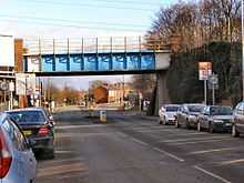
The current railway bridge at Mills Hill dates from 1934, replacing an older bridge dating to 1839. The new bridge allowed for double deck trams and buses to operate from Middleton to Chadderton for the first time.[14]
References
- ↑ http://www.millshillbaptistchurch.org/uploads/2/0/1/6/2016086/yesterday_today_and_forever_-_mills_hill_church_history.pdf
- ↑ Lawson, Michael; Johnson, Mark (1997), Images of England: Chadderton, Tempus, ISBN 0-7524-0714-7
- ↑ P.51 Chadderton Pubs And Their Licencees 1750 - 1999, Magee Rob (1986) ISBN 978 185216 134 7
- ↑ http://www.british-history.ac.uk/report.aspx?compid=53005
- ↑ http://www.millshillbaptistchurch.org/uploads/2/0/1/6/2016086/yesterday_today_and_forever_-_mills_hill_church_history.pdf
- ↑ http://www.millshillbaptistchurch.org/uploads/2/0/1/6/2016086/yesterday_today_and_forever_-_mills_hill_church_history.pdf
- ↑ Lawson, Michael; Johnson, Mark (1997), Images of England: Chadderton, Tempus, ISBN 0-7524-0714-7
- ↑ P.16 C6hadderton Pubs And Their Licencees 1750 - 1999, Magee Rob (1986) ISBN 978 185216 134 7
- ↑ http://www.genuki.org.uk/big/eng/LAN/Chadderton/MillsHillRdBaptist.shtml
- ↑ Chadderton Historical Society
- ↑ http://www.millshillbaptistchurch.org/uploads/2/0/1/6/2016086/yesterday_today_and_forever_-_mills_hill_church_history.pdf
- ↑ http://www.visionofbritain.org.uk/unit/10186780
- ↑ P112 Chadderton Chapters (1972), Lawson M, ISBN 0 9502475 0 2
- ↑ P39 - Lawson, Michael; Johnson, Mark (1990), Looking Back at Chadderton, Oldham Leisure Services, ISBN 0-902809-23-7
External links
Mills Hill Baptist Church - http://www.millshillbaptistchurch.org/index.html
Genuki.org: Mills Hill Baptist Church - http://www.genuki.org.uk/big/eng/LAN/Chadderton/MillsHillRdBaptist.shtml
Mills Hill Primary School - http://www.millshill.oldham.sch.uk/home/Neighbouringlocalities.BoarshawStakeHillChaddertonFoldTongeChaddertonParkWest MillsHill EastMoorcloseMiddletonJunctionFirwoodPark