Millerand Island
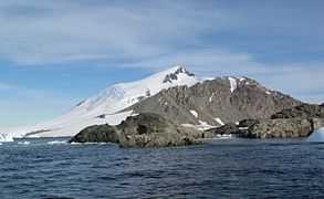 Millerand Island from San Martín Base, 2011 | |
 Location in Antarctica | |
| Geography | |
|---|---|
| Location | Antarctica |
| Coordinates | 68°09′S 67°13′W / 68.150°S 67.217°W |
| Length | 5 km (3 mi) |
| Width | 5 km (3 mi) |
| Country | |
|
None | |
| Demographics | |
| Population | Uninhabited |
| Additional information | |
| Administered under the Antarctic Treaty System | |
Millerand Island or Cap Millerand is a high rugged island 5 km (3 mi) in diameter, lying 6 km (4 mi) south of Cape Calmette, off the west coast of Graham Land. Millerand Island is located at 68°09′S 67°13′W / 68.150°S 67.217°W. Millerand Island was discovered by the French Antarctic Expedition (1908-1910) under Jean-Baptiste Charcot. Millerand Island was named by Jean-Baptiste Charcot, presumably for Alexandre Millerand, French statesman.
See also
- Composite Antarctic Gazetteer
- List of Antarctic and sub-Antarctic islands
- List of Antarctic islands south of 60° S
- SCAR
- Territorial claims in Antarctica