Mill River (Northampton, Massachusetts)
in Williamsburg
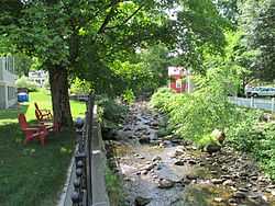
| Wikimedia Commons has media related to Mill River (Northampton, Massachusetts). |
The Mill River is a 13.5-mile-long (21.7 km)[1] tributary of the Connecticut River arising in the western hilltowns of Hampshire County, Massachusetts. It is notable for dropping in elevation, along with its West Branch, more than 700 feet (210 m) over 15 miles (24 km).
History
Dozens of mills were built along the Mill River in the early to mid 19th century to take advantage of the available waterpower. To maintain sufficient summer water flow four reservoirs were built in the higher tributaries of the river.
Mill River Flood of 1874
A dam holding back the Williamsburg Reservoir burst causing a flood along the Mill River on May 16, 1874, killing 139 people.[2] The flood destroyed much of the villages of Williamsburg, Skinnerville, and Haydenville in the town of Williamsburg, and the village of Leeds in the town of Northampton.
This flood was widely covered in contemporaneous newspapers across the United States.
Gallery
-

View of Mill River, Northampton, MA circa 1910.
External links
References
- ↑ U.S. Geological Survey. National Hydrography Dataset high-resolution flowline data. The National Map, accessed April 1, 2011
- ↑ Sharpe, Elizabeth M. (2007). In the Shadow of the Dam, The Aftermath of the Mill River Flood of 1874. Simon and Schuster. ISBN 1-4165-7264-3.
Coordinates: 42°23′59″N 72°43′57″W / 42.39972°N 72.73250°W