Mik'aya
| Mik'aya | |
|---|---|
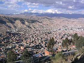 A view of La Paz with the Cordillera Real in the backgroud. Mik'aya lies in the sector shown in the upper left part of this image. Mururata is visible on the right. | |
| Elevation | 5,342 m (17,526 ft)[1] |
| Location | |
 Mik'aya Bolivia | |
| Location |
Bolivia, La Paz Department, Sud Yungas Province |
| Range | Andes, Cordillera Real |
| Coordinates | 16°21′59″S 67°56′09″W / 16.36639°S 67.93583°WCoordinates: 16°21′59″S 67°56′09″W / 16.36639°S 67.93583°W |
Mik'aya (Aymara for abyss in the water,[2] also spelled Mikhaya) is a 5,342-metre (17,526 ft) high mountain in the Cordillera Real in the Andes of Bolivia. It is located in the La Paz Department at the border of the Pedro Domingo Murillo Province, La Paz Municipality, and the Sud Yungas Province, Yanacachi Municipality. Mik'aya lies north-east of the city of La Paz, south-east of the mountains Ch'uñawi and Wak'ani and north of the mountains Jathi Qullu and Sirk'i Qullu.[3]
Mik'aya is also the name of a small lake at 16°21′45″S 67°57′19″W / 16.36250°S 67.95528°W and the name of a stream west of the mountain. The stream flows to the west along the lake Qhunqhu Wiqara (Kunco Huikara) and then to the south-west.[1]
See also
References
- ↑ 1.0 1.1 IGM map 1:50,000 6044-IV 'Chojlla'
- ↑ Félix Layme Pairumani, Diccionario Bilingüe Castellano - Aymara, Para: sexta Edición (Corregida y aumentada) 2010 (Spanish-Aymara dictionary)
- ↑ "Yanacachi". INE, Bolivia. Retrieved August 27, 2014. (labelled Mucaya)