Middle Franconia
| Middle Franconia (district) Mittelfranken | |
|---|---|
| Regierungsbezirk | |
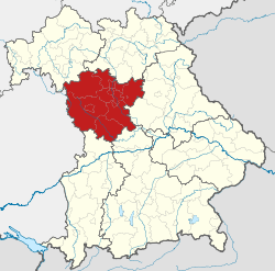 Map of Bavaria highlighting the Regierungsbezirk of Middle Franconia (district) | |
| Country | Germany |
| State | Bavaria |
| Region seat | Ansbach |
| Area | |
| • Total | 7,245.70 km2 (2,797.58 sq mi) |
| Population (31 December 2013)[1] | |
| • Total | 1,707,376 |
| • Density | 240/km2 (610/sq mi) |
| Website | regierung.mittelfranken.bayern.de |
Middle Franconia (German: Mittelfranken) is one of the three administrative regions of Franconia in Bavaria, Germany. It is in the west of Bavaria and adjoins the state of Baden-Württemberg. The administrative seat is Ansbach but the most populated city is Nuremberg.
Subdivisions
The region is divided into seven Landkreise (districts) and six kreisfreie Städte ('district-free cities'):
- Landkreise
- Kreisfreie Städte
Brief history
See also: Principality of Ansbach
The area, previously composed of independent principalities within the Holy Roman Empire, became a district of the Kingdom of Bavaria in Napoleonic times at the start of the 19th century. It gained its current name in 1838.
Coat of arms

Coat of Arms of Middle Franconia
The coat of arms displays:
|
Population
| Year | Inhabitants |
|---|---|
| 1900 | 815,895 |
| 1910 | 930,868 |
| 1939 | 1,065,122 |
| 1950 | 1,273,030 |
| 1961 | 1,371,144 |
| 1970 | 1,486,389 |
| 1987 | 1,521,484 |
| 2002 | 1,703,869 |
| 2005 | 1,712,275 |
| 2006 | 1,712,622 |
| 2008 | 1,714,453 |
| 2010 | 1,710,876 |
See also
- Upper Franconia (Oberfranken)
- Lower Franconia (Unterfranken)
References
External links
| ||||||||||||||