Messatida
| Messatida Μεσσάτιδα | |
|---|---|
|
Messatida municipal unit | |
 Messatida | |
|
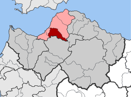
Location within the regional unit  | |
| Coordinates: 38°11′N 21°44′E / 38.183°N 21.733°ECoordinates: 38°11′N 21°44′E / 38.183°N 21.733°E | |
| Country | Greece |
| Administrative region | West Greece |
| Regional unit | Achaea |
| Municipality | Patras |
| • Municipal unit | 66.37 km2 (25.63 sq mi) |
| Elevation | 50 m (160 ft) |
| Population (2001)[1] | |
| • Municipal unit | 11,873 |
| • Municipal unit density | 180/km2 (460/sq mi) |
| Time zone | EET (UTC+2) |
| • Summer (DST) | EEST (UTC+3) |
| Postal code | 263 xx, 264 xx, 265 00 |
| Area code(s) | 2610 |
| Vehicle registration | ΑΧ |
Messatida (Greek: Μεσσάτιδα) is a former municipality in Achaea, West Greece, Greece. Since the 2011 local government reform it is part of the municipality Patras, of which it is a municipal unit.[2] The seat of the municipality was in Ovrya. It is located south of Patras city centre, and stretches from the urbanized plains near the Gulf of Patras to the Omplos hills in the east. The population was 11,873 in 2001. It has an area of 66.37 km².
Messatida was named after the ancient Achaean town Mesatis, according to local legend the place where Dionysus was reared.[3]
Population history
| Year | Population |
|---|---|
| 1991 | 9,583 |
| 2001 | 11,873 |
Subdivisions
The municipal unit Messatida is subdivided into the following communities (constituent villages in brackets):
- Kallithea (Kallithea, Ano Kallithea)
- Krini (Krini, Agios Kostantinos)
- Krystallovrysi
- Ovrya
- Petroto (Petroto, Mavromandila, Agia Paraskevi)
- Saravali (Saravali, Agios Stefanos, Demenika, Kefalovryso, Bakari)
- Thea (Thea, Lygies, Pavlokastro)
Sport Clubs
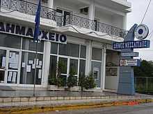
City Hall.
- Fostiras Ovrias FC (football)
- Achilleas Ovruas (football)
- Atlas Ovruas (football)
- Milon Ovruas (volleyball)
- Phoenix Ovruas (basketball)
- Achaios Saravali (football & Basketball)
- Galini Demenika (basketball,Ping pong,Baseball,Football,Softball)
- Krini 97' (basketball)
- A.O. Krini (football)
- A.O. Thea (football)
- A.O. Kalithea (football)
- Galaxias Demenika (basketball)
- Ikaros Petroto (football)
References
- ↑ De Facto Population of Greece Population and Housing Census of March 18th, 2001 (PDF 39 MB). National Statistical Service of Greece. 2003.
- ↑ Kallikratis law Greece Ministry of Interior (Greek)
- ↑ Pausanias Description of Greece 7.18
External links
| Wikimedia Commons has media related to Dimos Messatis. |
 |
Patras | Panachaikon | | |
| Paralia | |
|||
| ||||
| | ||||
| Vrachnaiika | Farres | Leontio |
| ||||||||||||||||||||||