Merrydale, Louisiana
| Merrydale | |
| Census-designated place | |
| Country | United States |
|---|---|
| State | Louisiana |
| Parish | East Baton Rouge |
| Elevation | 52 ft (15.8 m) |
| Coordinates | 30°30′15″N 91°06′58″W / 30.50417°N 91.11611°WCoordinates: 30°30′15″N 91°06′58″W / 30.50417°N 91.11611°W |
| Area | 4.3 sq mi (11.1 km2) |
| - land | 4.3 sq mi (11 km2) |
| - water | 0.0 sq mi (0 km2), 0% |
| Population | 10,427 (2000) |
| Density | 2,445.2 / sq mi (944.1 / km2) |
| Timezone | CST (UTC-6) |
| - summer (DST) | CDT (UTC-5) |
| Area code | 225 |
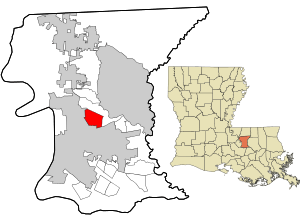 Location in East Baton Rouge Parish and the state of Louisiana.
| |
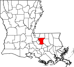
 Location of Louisiana in the United States
| |
Merrydale is a census-designated place (CDP) in East Baton Rouge Parish, Louisiana, United States. The population was 10,427 at the 2000 census. It is part of the Baton Rouge Metropolitan Statistical Area.
Geography
Merrydale is located at 30°30′15″N 91°6′58″W / 30.50417°N 91.11611°W (30.504289, -91.116195).[1]
According to the United States Census Bureau, the CDP has a total area of 4.3 square miles (11.0 km²), all of it land.
Demographics
| Historical population | |||
|---|---|---|---|
| Census | Pop. | %± | |
| 1990 | 10,395 | — | |
| 2000 | 10,427 | 0.3% | |
| source:[2] | |||
As of the census[3] of 2000, there were 10,427 people, 3,284 households, and 2,666 families residing in the CDP. The population density was 2,445.2 people per square mile (945.0/km²). There were 3,483 housing units at an average density of 816.8 per square mile (315.7/km²). The racial makeup of the CDP was 8.70% White, 90.18% African American, 0.09% Native American, 0.17% Asian, 0.20% from other races, and 0.66% from two or more races. Hispanic or Latino of any race were 0.90% of the population.
There were 3,284 households out of which 47.3% had children under the age of 18 living with them, 46.0% were married couples living together, 30.1% had a female householder with no husband present, and 18.8% were non-families. 16.4% of all households were made up of individuals and 4.9% had someone living alone who was 65 years of age or older. The average household size was 3.15 and the average family size was 3.52.
In the CDP the population was spread out with 34.6% under the age of 18, 10.9% from 18 to 24, 26.8% from 25 to 44, 20.9% from 45 to 64, and 6.8% who were 65 years of age or older. The median age was 29 years. For every 100 females there were 87.3 males. For every 100 females age 18 and over, there were 79.0 males.
The median income for a household in the CDP was $28,544, and the median income for a family was $30,289. Males had a median income of $27,745 versus $19,518 for females. The per capita income for the CDP was $10,664. About 28.6% of families and 31.6% of the population were below the poverty line, including 42.7% of those under age 18 and 26.7% of those age 65 or over.
References
- ↑ "US Gazetteer files: 2010, 2000, and 1990". United States Census Bureau. 2011-02-12. Retrieved 2011-04-23.
- ↑ "CENSUS OF POPULATION AND HOUSING (1790-2000)". U.S. Census Bureau. Retrieved 2010-07-17.
- ↑ "American FactFinder". United States Census Bureau. Retrieved 2008-01-31.
| |||||||||||||||||||||