Merrifield, Virginia
| Merrifield, Virginia | |
|---|---|
| Census-designated place (CDP) | |
 Location of Merrifield in Fairfax County, Virginia | |
| Coordinates: 38°52′23″N 77°14′35″W / 38.87306°N 77.24306°WCoordinates: 38°52′23″N 77°14′35″W / 38.87306°N 77.24306°W | |
| Country | United States |
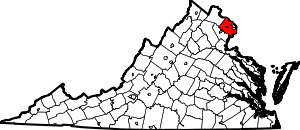
| State | Virginia |
| County | Fairfax |
| Area | |
| • Total | 2.7 sq mi (7.0 km2) |
| • Land | 2.7 sq mi (7.0 km2) |
| • Water | 0.0 sq mi (0.0 km2) |
| Elevation | 361 ft (110 m) |
| Population (2010) | |
| • Total | 15,212 |
| • Density | 5,600/sq mi (2,200/km2) |
| Time zone | Eastern (EST) (UTC-5) |
| • Summer (DST) | EDT (UTC-4) |
| Area code(s) | 703 |
| FIPS code | 51-51192[1] |
| GNIS feature ID | 1493280[2] |
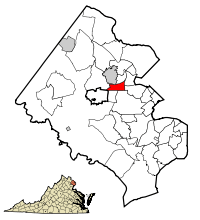
Merrifield is a census-designated place (CDP) in Fairfax County, Virginia, United States. The population was 15,212 at the 2010 census.
Geography
Merrifield is located at 38°52′23″N 77°14′35″W / 38.87306°N 77.24306°W (38.873144, −77.242994).[3] It is bounded by I-66 on the north, the Capital Beltway on the east, Arlington Boulevard on the south, and Nutley Street (Virginia State Highway 243) on the west.
According to the United States Census Bureau, the CDP has a total area of 2.7 square miles (7.0 km²), all of it land.
Demographics
As of the census[1] of 2000, there were 11,170 people, 4,396 households, and 2,725 families residing in the CDP. The population density was 4,107.2 people per square mile (1,585.6/km²). There were 4,534 housing units at an average density of 1,667.1/sq mi (643.6/km²). The racial makeup of the CDP was 54.67% White, 5.94% African American, 0.25% Native American, 29.94% Asian, 0.10% Pacific Islander, 5.00% from other races, and 4.11% from two or more races. Hispanic or Latino of any race were 12.91% of the population.
There were 4,396 households out of which 28.1% had children under the age of 18 living with them, 48.7% were married couples living together, 8.8% had a female householder with no husband present, and 38.0% were non-families. 25.0% of all households were made up of individuals and 3.5% had someone living alone who was 65 years of age or older. The average household size was 2.54 and the average family size was 3.06.
In the CDP the population was spread out with 19.4% under the age of 18, 10.3% from 18 to 24, 42.7% from 25 to 44, 21.4% from 45 to 64, and 6.2% who were 65 years of age or older. The median age was 33 years. For every 100 females there were 102.4 males. For every 100 females age 18 and over, there were 103.3 males.
The median income for a household in the CDP was $70,363, and the median income for a family was $74,116. Males had a median income of $55,653 versus $43,095 for females. The per capita income for the CDP was $32,819. About 5.3% of families and 7.4% of the population were below the poverty line, including 11.5% of those under age 18 and 5.8% of those age 65 or over.
Education
Fairfax County Public Schools operates public schools. The FCPS headquarters are located in the Gatehouse Administration Center in Merrifield.[4][5]
See also
- Dunn Loring (WMATA station)
- Merrifield Citizens Association
References
- ↑ 1.0 1.1 "American FactFinder". United States Census Bureau. Retrieved 2008-01-31.
- ↑ "US Board on Geographic Names". United States Geological Survey. 2007-10-25. Retrieved 2008-01-31.
- ↑ "US Gazetteer files: 2010, 2000, and 1990". United States Census Bureau. 2011-02-12. Retrieved 2011-04-23.
- ↑ "2010 Census Block Maps Merrifield, Virginia." U.S. Census Bureau. Retrieved on November 28, 2012.
- ↑ Contact Us. Fairfax County Public Schools. Retrieved on November 28, 2012. "Gatehouse Administration Center 8115 Gatehouse Road Falls Church, VA 22042"