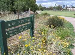
Merri Creek Trail
 | |
|---|---|
| Looking towards the city at Quarries Park | |
| Merri Creek Trail | |
| Length | Approx 21 km |
| Difficulty | Easy |
| Hills | Undulating |
| Hazards | Some blind corners, steep drop into creek, dog droppings on and beside trail, snakes |
| Path | Shared use concrete path |
| Connecting Transport | |
The Merri Creek Trail is a shared use path for cyclists and pedestrians that follows the Merri Creek through the northern suburbs of Melbourne, Victoria, Australia.[1][2][3]
Route
The path commences at Dights Falls near where Merri Creek enters the Yarra River, and then takes a winding route, mainly following the creek all the way to the Western Ring Road Trail. Hazards include a steep section, unmanageable to all but the most hardy cyclists and close to a school, at Heidleberg Road in Clifton Hill, and a missing section in North Fitzroy that requires leaving the river cutting to cross St. George's Road.
The route is now sealed for its entirety, with the last unsealed sections replaced in 2008. Along the way it passes by CERES, the Brunswick velodrome and the Coburg Lake park.
At the Western Ring Road Trail, heading west will lead you to the Moonee Ponds Creek Trail, Brimbank Park and the Maribyrnong River Trail. La Trobe University Bundoora campus can be accessed by following the trail east.
Landmarks
- CERES
- Brunswick velodrome
- Coburg Lake
- HM Prison Pentridge
Connections
- The path joins the Western Ring Road Trail in the north.
- In the south, it meets the Yarra River Trail.[4]
- In April 2010, connections to the Capital City Trail were improved with the addition of a new bridge across Merri Creek, 160m south of the junction of Union Street and Merri Parade.[5]
North end at 37°41′41″S 144°58′03″E / 37.694670°S 144.967497°E. South end at 37°46′59″S 144°59′33″E / 37.783139°S 144.992628°E.
Gallery
-
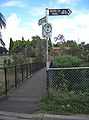
Footbridge to Rushall railway station
-
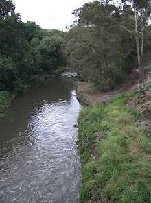
Revegetation
References
- ↑ VicRoads - Bicycle Facilities Map
- ↑ Melbourne and Geelong's shared paths in Google Maps
- ↑ Melbourne and Geelong's shared paths in Google Earth
- ↑ Kate Morgan (17 September 2013). "Two Minutes with Adalita | Magic Dirt". TheUrbanList.com. Urban List Pty Ltd. Retrieved 6 November 2013.
- ↑ Northcote Leader - bridge opening
- Bike rides around Melbourne 3rd edition, 2009, Julia Blunden, Open Spaces Publishing, ISBN 978-0-9752333-4-4
- Bike Paths Victoria sixth edition, 2004. Edited and published by Sabey & Associates Pty Ltd. pp124. ISBN 0-9579591-1-7
External links
- Merri Creek Management Committee
- Friends of Merri Creek
- Merri Creek Trail Map: Darebin City Council
 Geographic data related to Merri Creek Trail at OpenStreetMap
| ||||||||||