Merchant's Railway
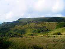
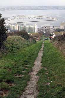
Merchant's Railway was a horse drawn and cable operated incline railway on the Isle of Portland, Dorset, England, built for the stone trade on the island. It was the earliest railway on Portland and in Dorset, opening in 1826 (one year after the Stockton and Darlington railway). The railway ran two miles from many working quarries at the north of Tophill, such as Tout, King Barrow and Waycroft Quarries, along the edge of Verne Hill (where the Verne Citadel is located), to a pier at Castletown, from where the Portland stone was shipped around the country. It was operation from 1826 to 1939. Since becoming disused the original path of the railway has become a popular public footpath, much like the nearby Rodwell Trail starting in Weymouth - the path of the now-disused Weymouth and Portland Railway. The remaining earthworks of the main line, amongst other remains, can still be traced today.
History

The Merchant's Railway was formed by various quarry owners, who wanted to promote a scheme for a railway from Tophill to Castletown's waterfront. The owners wished to create a railway that would allow for the passage of stone from Priory Corner down to sea level. At Priory Corner, the stone would be transferred from horse-drawn carts (later replaced by a network of quarry tramways) that served the Tophill quarries. Before the railway's construction, the method of transporting stone down the steep escarpments separating Tophill and Underhill had been by horse-drawn carts. These used a combination of blocks of stone on timber sled rails and horses known as Ape Horses tethered to the rear to act as breaks. However this method was deemed as cruel, and one eye-witness account from 1804 describes how the horses "squat down on their haunches and suffer themselves to be dragged for many yards, struggling with all their strength against the weight that forces them forwards".[1] Portland Railway Company had been founded in 1825 by seventeen quarry agents, five of which were of the Tucker-Steward family. The company plans for the railway was given an Act of Parliament on 10 October 1825, on condition that any tramway or construction would not constrain the defence of Portland Castle in any way. The Crown Estate also granted permission to build the railway on common land, though there were many local citizens who were against the loss of such land.[2]
During the following year, 1826, the original railway track was constructed by engineer James Bown, for a total cost of £5869.[3] This was achieved by cutting a ledge into the steeply sloping hillside from Priory Corner, crossing through Old Hill, and past the Rectory of St. George's Church, along a level crossing at the top of Tillycombe and then following the contours around the mass of Verne Hill to meet the head of the Freeman's Incline Railway. From this point the stone would be taken to the sheltered stone piers situated on the east side of Portland Castle, from where stone would be shipped all over the world. In order to maintain and preserve the cutting, a mix of large blocks of quarried stone and dry stone walls were placed, and the track rails laid to a gradual gradient and set onto stone sleepers. Marking each quarter of a mile from Priory Corner, stone posts were set up to enable the calculation of rates of carriage for the different grades of stone.[1] With the ease of transporting stone from the various working quarries, Priory Corner became the railway's prime loading area, and a stone tollhouse as well as a single derrick were soon added to the site.[2]

The track of the railway was laid on 27 March 1826 and on 23 August 1826 the railway was declared ready for operational use. A celebratory opening event saw locals and visitors come together, and a grand evening dinner was served at the Royal Portland Arms. Immediately the railway proved to be a successful and lucrative operation, and soon the majority of stone workings were transported using the railway. Due to this many original stone shipping piers along the east coastline of Portland, such as King's Pier, Folly Pier and Durdle Pier, started to fall into disuse. By 1828 the railway was carrying over 300 tons of stone a day, and the line was soon extended into quarries at West Cliff. This expansion would continue in the near future when many horse-drawn tramways were laid across Tophill.[4]
To conquer the descend of the various steep gradients of the railway, namely the Freeman's Incline, a counterbalance method was used. A heavily loaded wagon of stone, once descending, would be counterbalanced by a sufficient number of empty wagons ascending.[5] A pair of overhead break drums were put in place to serve the two stages of the Freeman's Incline. A chain would be wrapped around six foot diameter cylindrical timber drums mounted on timber frames and were later, in 1854, 'housed' with roof structures to offer protection from weathering. The chain and later, wire cable, were guided by steel rollers on pedestals partially set into the ground at intermediate points down the inclines. However the use of a chain had proved immediately troublesome due to the extreme weight often exerted on it. In 1860 the decision was made to remove the lower drum and replace the top drum with a wire cable system consisting of a horizontal pulley carrying the wire cable with a break wheel mounted above it. This new breaking method proved to be more successful, however excessive torque on the break wheel resulted in cable slippage. In 1905 this was solved by installing a new eight foot diameter pulley wheel and improved breaking system.[1] A narrow gauge bridge within close distance to Freeman's Incline remains in existence today.[6]
In 1866 the railway had become increasingly in demand from the quarries and to accommodate the continuing surge of traffic, a second, upper track was cut into Verne Hill, again linking from the top of Tillycombe to the Freeman's Incline. This event coincided with the construction of the 19th century 56 acre fortress Verne Citadel, as well as the opening of the Portland Branch Railway the previous year. With this new railway operational, a short branch from Portland Station at Victoria Square to a pair of sidings at the foot of the Freeman's Incline enabled the transferring of stone from the non-standard gauge of four feet, six and a half inches of the Merchant's Railway to the standard four feet, eight and a half inch gauge of the main line wagons.[5] Whilst the southern face of Verne Hill went through remodeling during construction of the citadel, an existing fresh water spring head was housed in a stone retaining wall, known as the Verne Cistern, cut into the outer wall of the Verne Ditch bank, midway along and adjacent to the upper track. The spring would also supply water to two large stone drinking troughs located below on the lower track.[1]
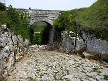
Yeates Incline was built as an addition to the main line to serve Withies Croft, Independent, and Inmosthay Quarries, whilst it was also constructed to replace an earlier incline to the east, removed in 1866 to allow for the construction of the South Gate of the Verne Citadel. For this incline four bridges were constructed, all of which are dated between 1875-82. The lower bridge carried the road up from Fortuneswell to the South Gate, the line from Waycroft Quarry crossed the middle bridge, whilst the top road from Verne Yeates to the South Gate crossed the two upper bridges. To enable the use of wire cable, an overhead twelve foot diameter timber break drum was installed at the head. Three of the bridges became Grade II Listed in 1978, and the fourth became Grade II Listed in 1993. All remain intact and in use today, either as part of a road or footpath.[7][8][9][10] The keystones of the upper bridge and middle bridge have inscribed dates of 1882 and 1880 respectively, whilst the lower bridge is slightly earlier having a date of 1875 inscribed on the inner face of the parapet adjacent to the keystone. The bridge abutments are constructed with rough-hewn, quarry-dressed masonry blocks of Portland Stone set in random coursing. The quoins are of rusticated ashlar with a drafted margin, as are the voussoir stones forming the arches and the bridge rebates and soffits are of dressed ashlar laid in courses. A fourth bridge, serving Waycroft Quarry, lies to the west of the incline and has an inscribed date of 1881.[1] The railway reached its commercial peak in 1895, to which the year had seen 81,000 tons of stone transported.[11]
The traffic on the railway began to decline in graduation with the introduction of traction engines on Portland during the early 1890s. By the 1930s diesel lorries were also seeing increasing use to transport stone by road, and this caused a further decline of use of the railway. During World War I, the track of the Yeates lncline was removed, and during this same time stone industry suffered a natural slump and quarrying ceased. The railway continued operating until 1917, when it closed for three years before reopening in 1920.[12] Later on the outbreak of World War II, quarrying was again temporarily halted, however this time the Merchant's Railway became disused for good on 11 October 1939. Later an attempt by the Easton and Church Hope Railway to take the Merchant's Railway over failed at the parliamentary stage, partly as the line was at any event not standard gauge and the stock not compatible with main line standards. However the Portland Railway Company continued to be in existence until 1972, and by this point the company had sold their land to offset liabilities and costs. The break house building serving the Freeman's lncline was then demolished, and the rails removed for scrap, although many remaining rails were used as reinforcement for the Chiswell sea defence wall and promenade constructed from 1958 to 1965.[1] It has been calculated that during the railway's use, approximately 704.93672 tons of stone travelled down the incline.[13]
In 2008, the Merchant's Railway, along with the Weymouth and Portland Railway, were the subjects of an episode of Julia Bradbury's Railway Walks, a BBC factual programme. The episode, titled "Harbouring History", aired on 30 October 2008 on BBC Four, and later appeared as part of the series DVD and book release in 2009. The DVD, combining the entire series, featured Bradbury at the Yeates Incline.[14]
References
- ↑ 1.0 1.1 1.2 1.3 1.4 1.5 "Portlandbill.co.uk". Portlandbill.co.uk. 1939-10-11. Retrieved 2014-05-04.
- ↑ 2.0 2.1 Morris, Stuart (1985). Portland: An Illustrated History. Dovecote Press. p. 56. ISBN 978-0946159345.
- ↑ http://www.pastscape.org.uk/hob.aspx?hob_id=868120&sort=2&type=&rational=a&class1=None&period=None&county=93347&district=93625&parish=93626&place=&recordsperpage=10&source=text&rtype=&rnumber=&p=16&move=n&nor=294&recfc=0
- ↑ Morris, Stuart (1985). Portland: An Illustrated History. Dovecote Press. p. 57. ISBN 978-0946159345.
- ↑ 5.0 5.1 "Fortuneswell, Portland, Dorset". Geoffkirby.co.uk. Retrieved 2014-05-04.
- ↑ "Portland Walk". Lococarriage.org.uk. Retrieved 2014-05-04.
- ↑ "1203102 - The National Heritage List for England | English Heritage". List.english-heritage.org.uk. 1993-05-17. Retrieved 2014-05-04.
- ↑ "1203122 - The National Heritage List for England | English Heritage". List.english-heritage.org.uk. Retrieved 2014-05-04.
- ↑ "1205878 - The National Heritage List for England | English Heritage". List.english-heritage.org.uk. Retrieved 2014-05-04.
- ↑ "1206274 - The National Heritage List for England | English Heritage". List.english-heritage.org.uk. Retrieved 2014-05-04.
- ↑ Morris, Stuart (1985). Portland: An Illustrated History. Dovecote Press. p. 86. ISBN 978-0946159345.
- ↑ Morris, Stuart (1985). Portland: An Illustrated History. Dovecote Press. p. 120. ISBN 978-0946159345.
- ↑ "Remembering island's railway (From Dorset Echo)". Dorsetecho.co.uk. 2014-02-25. Retrieved 2014-05-04.
- ↑ "Railway Walks with Julia Bradbury [DVD]: Amazon.co.uk: Julia Bradbury: DVD & Blu-ray". Amazon.co.uk. Retrieved 2014-05-04.
| ||||||||||||||||||||||||||||||||||||||||||||||||||||||||||||||||||