Mer de Glace
| Mer de Glace | |
|---|---|
| Sea of Ice | |
|
Mer de Glace | |
 Mer de Glace located in France Map | |
| Location | Northern slopes of the Mont Blanc massif |
| Coordinates | 45°54′58″N 6°56′14″E / 45.91611°N 6.93722°ECoordinates: 45°54′58″N 6°56′14″E / 45.91611°N 6.93722°E |
| Length | 7 km (4.3 mi) |

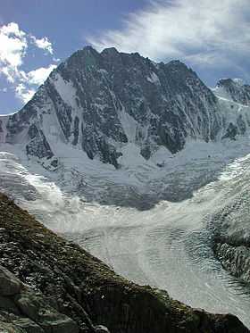
The Mer de Glace (Sea of Ice) is a glacier located on the northern slopes of the Mont Blanc massif, in the Alps. At 7 kilometres (4.3 mi) long and 200 metres (660 ft) deep, it is the longest glacier in France.[1]
Geography

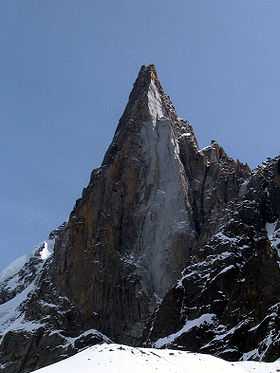
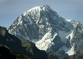
It originates at an elevation of 2,400 metres (7,900 ft) where it is fed by the confluence of Glacier du Géant, Glacier de Lechaud, and Cascade du Talèfre, north of Mont Tacul, and descends to 1,400 metres (4,600 ft). It flows north-north-west between Aiguille du Moine on the east and Trélaporte on the west. Le Grand Dru lies to the north east. It was once easily visible from Chamonix, but has been shrinking and is now barely visible from below.[2]
It lies in the Chamonix valley, it was the first place in the valley to have a ready-made tourist attraction.
The Mer de Glace, like all glaciers, is constantly renewed by two phenomena: accumulation, notably due to snowfall and ablation, essentially due to melting. The Mer de Glace flows permanently under the effect of its own weight, causing crevasses, seracs or pockets of water to form, depending on the type of ground.
The glacier's speed, although not perceptible to the naked eye, is considerable. From more than 120 metres (390 ft) a year in its upper part, the Mer de Glace moves about 90 metres (300 ft) per year in the region of Montenvers, which is about one centimeter per hour.
When the tension in the ice increases the glacier is deformed and crevasses appear. These are notably transversal and, when there is intense crevasse activity, blocks of seracs appear as the glacier breaks up. These crevasses are of variable depth, depending on their position, and may be as deep as fifty metres. They always form in the same place because of the shape of the glacial valley in which the glacier flows. Disappearing downstream, they are renewed upstream.
History

In the 18th and 19th centuries the glacier descended all the way down to the hamlet of Les Bois,[2] where it was known as Glacier des Bois. At that time the river Arveyron emerged from the glacier under a grotto-like vault (grotte d'Arveyron)[3] and attracted painters and later photographers, for example Joseph Mallord William Turner's "Source of the Arveron in the Valley of Chamouni Savoy", 1816. The position of its front end fluctuated over the years but its maximum extent was in the mid-19th century.[2]
Electricity Generation
Sub glacial waters from the Mer de Glace are used seasonally by EDF for the generation of hydroelectricity. Tunnels bored under the glacier collect water from the base of the glacier and channel it down to a hydropower plant in the valley. This water is then discharged into the Arveyron further downstream.
See also
Notes
References
- Jean M. Grove (1988). The Little Ice Age. ISBN 0-415-01449-2.
- John Tyndall (1896). The Glaciers of the Alps. Longmans, Green and Co. NEW EDITION (reprinted as ISBN 1-4212-0908-X)
External links
| Wikimedia Commons has media related to Mer de Glace. |
- Official site of the city of Chamonix Mont-Blanc (French)
- Chamonix Valley info and weather
- Skiing the Vallee Blanche and Mer de Glace
- Collection of videos of skiing in la Mer De Glace
- Collection of images of crevasses of la Mer De Glace