Menidi, Aetolia-Acarnania
| Menidi Μενίδι | |
|---|---|
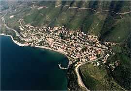 | |
 Menidi | |
|
Location within the regional unit 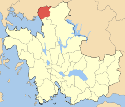 | |
| Coordinates: 39°2.517′N 21°7.069′E / 39.041950°N 21.117817°ECoordinates: 39°2.517′N 21°7.069′E / 39.041950°N 21.117817°E | |
| Country | Greece |
| Administrative region | West Greece |
| Regional unit | Aetolia-Acarnania |
| Municipality | Amfilochia |
| • Municipal unit | 107.73 km2 (41.59 sq mi) |
| Elevation | 30 m (100 ft) |
| Highest elevation | 798 m (2,618 ft) |
| Lowest elevation | 0 m (0 ft) |
| Population (2001)[1] | |
| • Municipal unit | 2,037 |
| • Municipal unit density | 19/km2 (49/sq mi) |
| Time zone | EET (UTC+2) |
| • Summer (DST) | EEST (UTC+3) |
| Postal code | 300 16 |
| Area code(s) | 26810 |
| Vehicle registration | AΙ_ |
| Website | www.menidi.gr |
Menidi (Greek: Μενίδι) is a former municipality in Aetolia-Acarnania, West Greece, Greece. Since the 2011 local government reform it is part of the municipality Amfilochia, of which it is a municipal unit.[2] It is located by the Ambracian Gulf. Its economy is based on tourism and agriculture. It was built in the 1950s under an official government plan to house victims of the Greek Civil War and other families who did not own houses. Today is a popular destination for Greek and foreign tourists.
Subdivisions
The municipal unit Menidi is subdivided into the following communities (constituent villages in brackets):
- Menidi (Menidi, Elaiochori, Theriakisi, Katsouli, Lagkada, Sykoula)
- Floriada (Floriada, Elaiofyto, Katharovouni, Kastriotissa, Palaia Floriada, Palaiokastro, Chrysopigi, Chrysorrachi)
Historical population
| Year | City population | Municipal district population |
|---|---|---|
| 1981 | 703 | 2,347 |
| 1991 | 921 | 2,404 |
| 2001 | 1,055 | 2,442 |
| 2011 | 852 | 2,032 |
References
- ↑ De Facto Population of Greece Population and Housing Census of March 18th, 2001 (PDF 39 MB). National Statistical Service of Greece. 2003.
- ↑ Kallikratis law Greece Ministry of Interior (Greek)
External links
- Menidi (official web site) (Greek) (English)
- Menidi (municipality) on GTP Travel Pages (Greek) (English)
- Menidi (community) on GTP Travel Pages (Greek) (English)
See also
| ||||||||||||||