Mendenhall Glacier
| Mendenhall Glacier | |
|---|---|
|
Mendenhall Glacier and frozen Mendenhall Lake | |
| Type | Mountain glacier |
| Location | Coast Range, Juneau Borough, Alaska, United States |
| Coordinates | 58°29′45″N 134°31′56″W / 58.49583°N 134.53222°W[1]Coordinates: 58°29′45″N 134°31′56″W / 58.49583°N 134.53222°W[2] |
| Terminus | Proglacial lake |
| Status | Retreating |
.jpg)
.jpg)

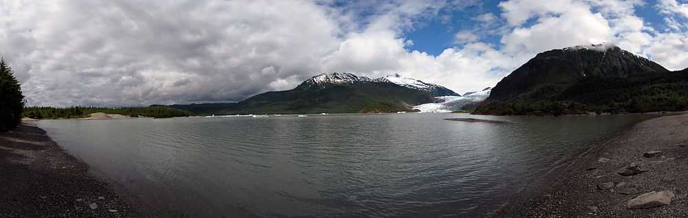
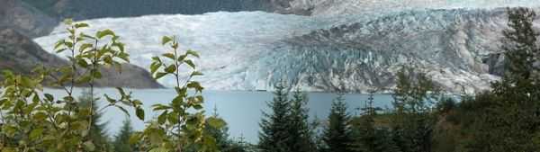
Mendenhall Glacier is a glacier about 12 miles (19 km) long located in Mendenhall Valley, about 12 miles (19 km) from downtown Juneau in the southeast area of the U.S. state of Alaska. The glacier and surrounding landscape is protected as the 5,815-acre Mendenhall Glacier Recreation Area, a federally designated unit of the Tongass National Forest.[3]
Originally known as Sitaantaagu ("the Glacier Behind the Town") or Aak'wtaaksit ("the Glacier Behind the Little Lake") by the Tlingits, the glacier was named Auke (Auk) Glacier by naturalist John Muir for the Tlingit Auk Kwaan (or Aak'w Kwaan) band in 1888. In 1891 it was renamed in honor of Thomas Corwin Mendenhall. It extends from the Juneau Icefield, its source, to Mendenhall Lake and ultimately the Mendenhall River.
The Juneau Icefield Research Program has monitored the outlet glaciers of the Juneau Icefield since 1942, including Mendenhall Glacier. The glacier has also receded 1.75 miles (2.82 km) since 1958, when Mendenhall Lake was created, and over 2.5 miles (4.0 km) since 1500. The end of the glacier currently has a negative glacier mass balance and will continue to retreat in the foreseeable future.[4]
Given that average yearly temperatures are currently increasing, and the outlook is for this trend to continue, it is actually possible that the glacier might experience a period of stabilization or slight advance during its retreating march. This is because increasing amounts of warm, moist air will be carried up to the head of the icefield, where colder ambient temperatures will cause it to precipitate as snow. The increased amount of snow will feed the icefield, possibly enough to offset the continually increasing melting experienced at the glacier's terminus. However, this interesting phenomenon will fade away if temperatures continue to climb, since the head of the glacier will no longer have cold enough ambient temperatures to cause snow to precipitate.
The glacier's retreat
Climate change
Climate change is causing glaciers to melt faster than they would naturally. Since approximately the middle of the twentieth century, according to the IPCC, human activities have released increasing amounts of carbon dioxide and other greenhouse gases into the atmosphere. These greenhouse gases are a product of humans burning fossil fuels to produce energy. Deforestation, industrial processes, and some agricultural practices emit gases into the atmosphere as well. This emission of greenhouse gases. As temperatures rise and ice melts, water flows from the glaciers and ice caps causing the water to warm and expand.[5]
Negative consequences
The retreat of the Mendenhall Glacier and other glaciers in the area is a result of broader retreat and breakup of the Juneau Icefield. The Juneau Icefield is the fifth largest icefield in North America.[6] To determine negative effects of glacial retreat we are able to look at other glaciers around the world and apply negative effects they experience to the recession of the Mendenhall glacier. For many populations near glacial areas these glaciers are a source of fresh drinking water. Once these glaciers are gone the people relying on this fresh water will be out of their familiar fresh water source. For example, Anchorage is one of the most populated cities in Alaska and many people in this city rely on the Eklutna glacier for their freshwater. If the recession of this glacier continues they will be out of their main source of water.[7][8]
Benefits
Although there are many negative affects of the recession of the Mendenhall glacier and glaciers in general, there are also a few positive outcomes from it as well. With the recession of the Mendenhall glacier, the Mendenhall Lake has formed. The lake is a result of the run-off from the glacier and is increasing in size as recession continues. The lake began formation in 1931 and has continued to grow since then.[9] The lake has its own unique ecosystem and is a popular location for sport fishing; fishers can find salmon and trout in the lake.[10]
Ancient forest uncovered
As of recently a new discovery has been made regarding the Mendenhall glacier and its recession. Within the past year, tree stumps and logs with roots and bark still attached have been appearing from under the glacier as it has been retreating. They are being found in their original growth position, preserved by what was believed to be a protective gravel casing covering them. By uncovering these tree stumps and logs, scientists are able to uncover information on the ecosystem's past, from a pre-glacier time. Scientists observing the area are able to determine how old the trees were when they died by looking at their preserved remains. [7][11]
Visitor Center
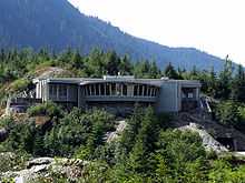
The United States Forest Service operates the Mendenhall Glacier Visitor Center as part of the Tongass National Forest, offering interpretive programs throughout the year for children and adults. The Mendenhall Glacier Visitor Center and surrounding area offers stunning views of a lake-terminating, calving glacier. The center is open year-round and receives close to 500,000 visitors each year, many coming by cruise ship in summer. There are two accessible entrances – an upper entrance with a ramp and a lower entrance with elevators.
This was the first U.S. Forest Service visitor center built in the nation. Designed by Linn A. Forrest and dedicated in 1962, a restaurant originally served pie and coffee in the area of the center that now offers books, videos and souvenirs to glacier visitors. The building was expanded, renovated and rededicated in 1999. Exhibits in the Center cover the history of Mendenhall Glacier showing how it covered the valley when Joseph Whidbey, master of the HMS Discovery during George Vancouver's 1791–95 expedition, toured the area in 1794 and what is happening due to climate change today. The exhibits depict the variety of wildlife in the area including mountain goats, wolves, black bears and salmon in the nearby streams. Rangers provide interpretive information, children's nature programs, point out wildlife and answer questions about the area.
There are two small parking lots with access to several trails in the area. Photo Point Trail and the Steep Creek Trail are easy and accessible trails. Elevated boardwalks above Steep Creek provide salmon and bear viewing opportunities. Visitors can hike via the East Glacier Loop to an overlook within a half-mile of the glacier. Two routes traverse a series of wooden steps and a gradual elevation gain of 500' on this trail. The Trail of Time, which connects to East Glacier Loop, was recently updated to include new historical signs and handicap accessibility. You can also explore the recently completed 0.8-mile Nugget Falls Trail, which leads you to Nugget Falls near the face of the glacier.[12] Access to the area and trails is free. The West Glacier trail also offers the chance to view ice caves beneath the glacier.
From May through September, there is a $3 admission fee to go into the visitor center to view the exhibits and see audio-visual presentations. Activities outside the center building itself are free of charge, and visitors may use the restrooms and visit the bookstore without paying the fee. This fee provides for maintenance of the trails, programs during summer, and updating the exhibits in the center. There is no fee in the winter.
In addition to the busy summer season, the Center hosts the Fireside Lecture series on Friday evenings, January through March. Programs cover the ecological and culture history and events in Southeast Alaska. Inside the Visitor Center is a natural and cultural history bookstore run by Alaska Geographic, which is a non-profit organization supporting the public lands of Alaska. Trail guides, wildlife and bird guides, children books and other materials are available here from May through September.
Gallery


See also
References
- ↑ "Mendenhall Glacier". Geographic Names Information System. United States Geological Survey. Retrieved 2012-07-14.
- ↑ "Mendenhall Glacier". Geographic Names Information System. United States Geological Survey. Retrieved 2012-07-14.
- ↑ Mendenhall Glacier Recreation Area Planning, United States Forest Service
- ↑ Alaska Looks for Answers in Glacier’s Summer Flood Surges July 22, 2013 New York Times
- ↑ "Signs from Earth: The Big Thaw". Retrieved 17 October 2013.
- ↑ "A Case Study: Then Mendenhall Glacier". Retrieved 17 October 2013.
- ↑ 7.0 7.1 Poppick, Laura (20 September 2013). "Ancient Forest Thaws From Melting Glacial Tomb". livescience. Retrieved 12 November 2013.
- ↑ Pappas, Stephanie (December 8, 2011). "Shrinking Glaciers Point to Looming Water Shortages". Retrieved 17 October 2013.
- ↑ Motyka, Roman (March 14, 2002). "Twentieth Century Thinning of Mendenhall Glacier, Alaska, and its Relationship to Climate, Lake Calving, and Glacier Run-Off" (PDF). Retrieved 17 October 2013.
- ↑ "Haines-Skagway Sport Fishing Locations" (PDF). Retrieved 17 October 2013.
- ↑ Ancient trees emerge from frozen forest 'tomb'
- ↑ Nugget Falls Trail – Tongass National Forest
External links
| Wikimedia Commons has media related to Mendenhall Glacier. |
- Mendenhall Glacier, Tongass National Forest
- Mendenhall Glacier Visitor Center on Twitter
- Terminus Behavior of Juneau Icefield Glaciers 1948–2005
- Ancient Forest Thaws From Melting Glacial Tomb