Melverley
Melverley is a village in Shropshire, England, situated on the River Severn and the River Vyrnwy, near the Powys hills and the border with Wales. The village, and the large rural area that surrounds it, was years ago famous for flooding from the nearby rivers but since the extensive defences being installed in Shrewsbury and improvements to the flood defences in and around the Melverley area flooding causes no problems for the majority of residents. It is a controlled flood area, meaning that water is allowed to flow across the open fields and held for a few hours until the river levels fall. Melverley Green is a small village to the north of Melverley.
St Peter's Church
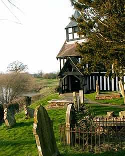
The notable building in Melverley is the black and white timber-framed St Peter's Church which stands on the banks of the River Vyrnwy; it is one of only three such churches to be found in Shropshire and the oldest of its kind. The church was rebuilt in 1406 after Owain Glyndŵr burnt it to the ground. The church has a Jacobean pulpit and a chained bible (also known as a "Great Bible"). It is thought that the design of St Peter's may have inspired the architecture of St Andrew's Episcopalian church in Newcastle, Maine.
Melverley and the "Potts Line"
Melverley was situated on the Potts Railway Line designed to link Shrewsbury with the small village of Llanymynech, near Oswestry. Unlike many stops on the line, the station at Melverley had a brick shed for waiting passengers (many stations had wooden facilities and timber platforms). A viaduct was built at Melverley in order for the line to cross the Severn but this crashed into the river in 1902. The viaduct was rebuilt to enable the re-opening of the line on April 13, 1911. It was subsequently declared unsafe on several occasions and was a contributory factor to the demise of the Potts Line.
Today, little evidence of the railway remains at Melverley save for some bricks marking the platform edge. However, a road has been built along the course of part of this branch line to Criggion utilizing the old railway bridge over the Severn and making a convenient connection to the main road at Crew Green. This is a single-track road with passing places but is unusually direct and level compared to other country lanes in the area.
Further reading
External links
![]() Media related to Melverley at Wikimedia Commons
Media related to Melverley at Wikimedia Commons
Coordinates: 52°44′N 2°59′W / 52.733°N 2.983°W
| ||||||||||||||||||||||